732
WWUS83 KIND 170608
SPSIND
Special Weather Statement
National Weather Service Indianapolis IN
208 AM EDT Sun Aug 17 2025
INZ051-052-060-061-170645-
Clay IN-Greene IN-Vigo IN-Sullivan IN-
208 AM EDT Sun Aug 17 2025
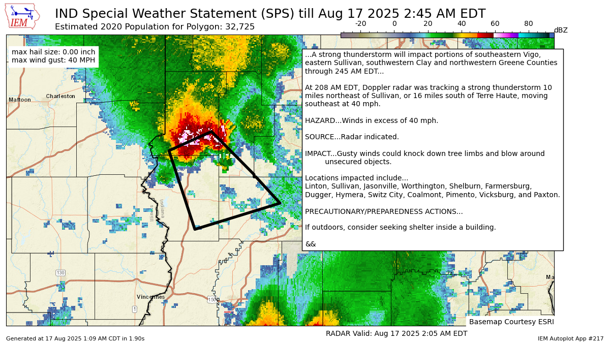
...A strong thunderstorm will impact portions of southeastern Vigo,
eastern Sullivan, southwestern Clay and northwestern Greene Counties
through 245 AM EDT...
At 208 AM EDT, Doppler radar was tracking a strong thunderstorm 10
miles northeast of Sullivan, or 16 miles south of Terre Haute, moving
southeast at 40 mph.
HAZARD...Winds in excess of 40 mph.
SOURCE...Radar indicated.
IMPACT...Gusty winds could knock down tree limbs and blow around
unsecured objects.
Locations impacted include...
Linton, Sullivan, Jasonville, Worthington, Shelburn, Farmersburg,
Dugger, Hymera, Switz City, Coalmont, Pimento, Vicksburg, and Paxton.
PRECAUTIONARY/PREPAREDNESS ACTIONS...
If outdoors, consider seeking shelter inside a building.
&&
LAT...LON 3936 8728 3918 8705 3917 8705 3917 8704
3906 8691 3895 8737 3928 8751
TIME...MOT...LOC 0608Z 325DEG 36KT 3924 8733
MAX HAIL SIZE...0.00 IN
MAX WIND GUST...40 MPH
$$
GM
https://mesonet.agron.iastate.edu/p.php?pid=202508170608-KIND-WWUS83-SPSIND
Warnings always on My Huge Radar!
Never miss me! Subscribe for free. My Huge Radar has real-time weather tracking, current temperatures, and severe weather watches and warnings. Get detailed Indiana conditions by clicking here. Click here to see my central Indiana 7-Day Forecast. Follow these links to get my forecasts for Lafayette, Muncie, Hendricks County, and Hamilton County. Need a second opinion? Click here for central Indiana National Weather Service forecasts. (Some charts via WeatherBELL.)


