HEADLINES
– Not quite as hot or humid today. Heat back tomorrow, humidity increases Friday night.
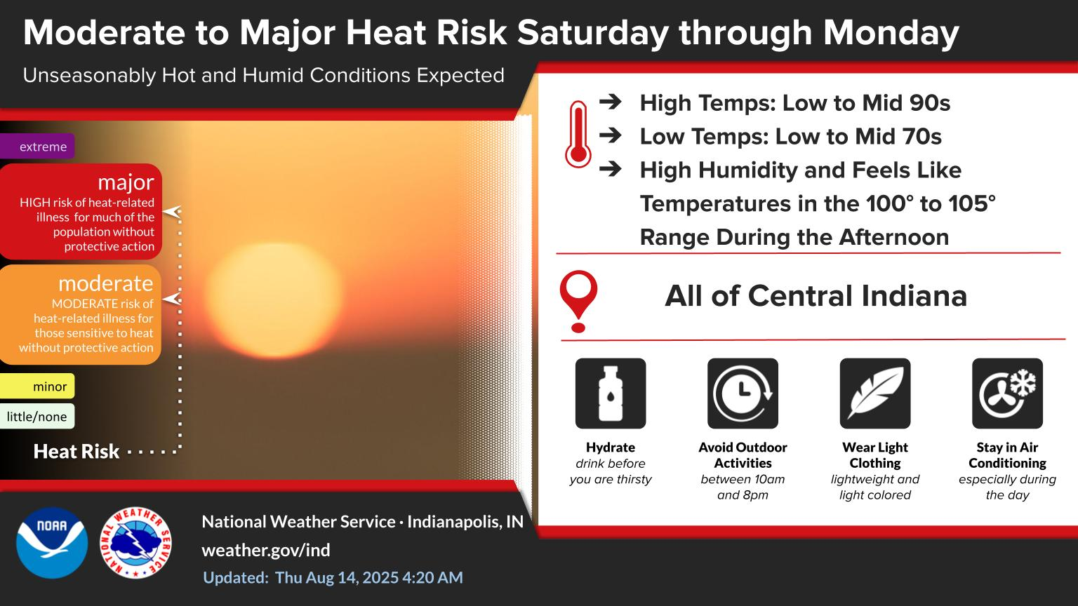
– Heat index near or just over 100 at times Saturday through Monday.
– Best next storm chance is Tuesday and Wednesday, ahead of a cold front.
– Next Thursday and Friday should feature temps a little BELOW average.
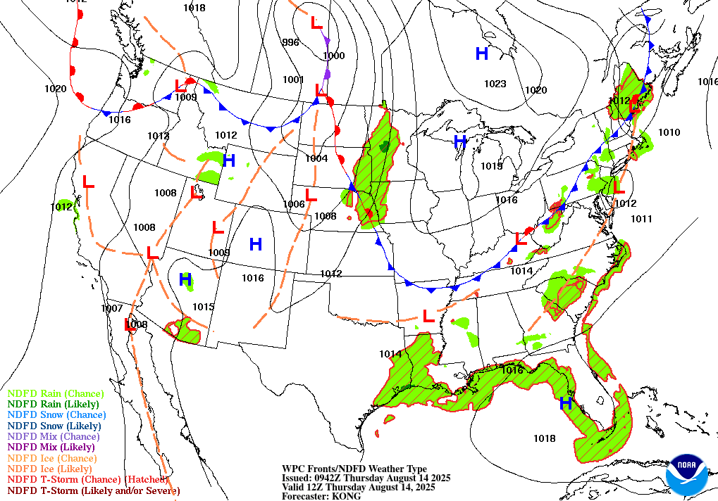
TODAY’S MAP
NWS TECHNICAL DISCUSSION
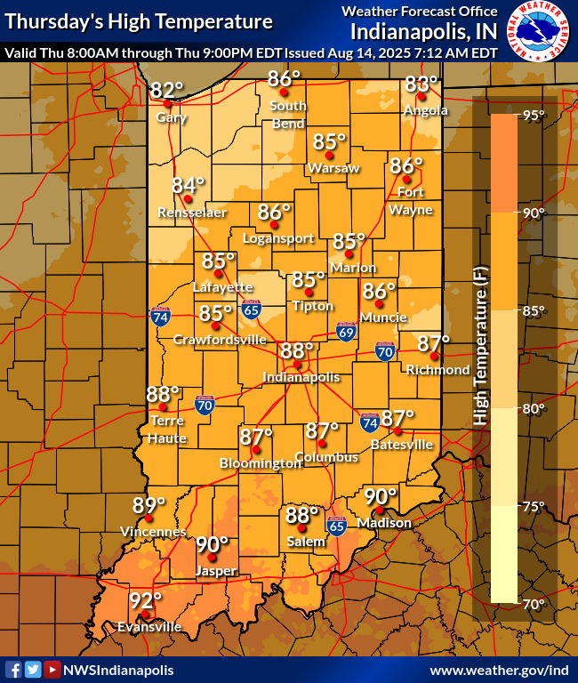
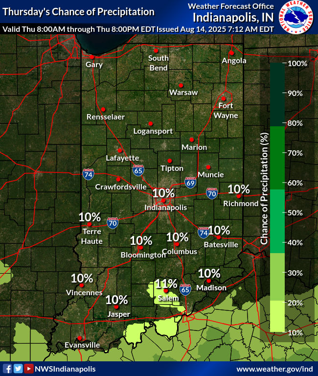
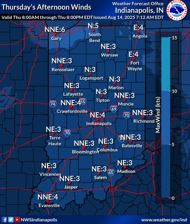
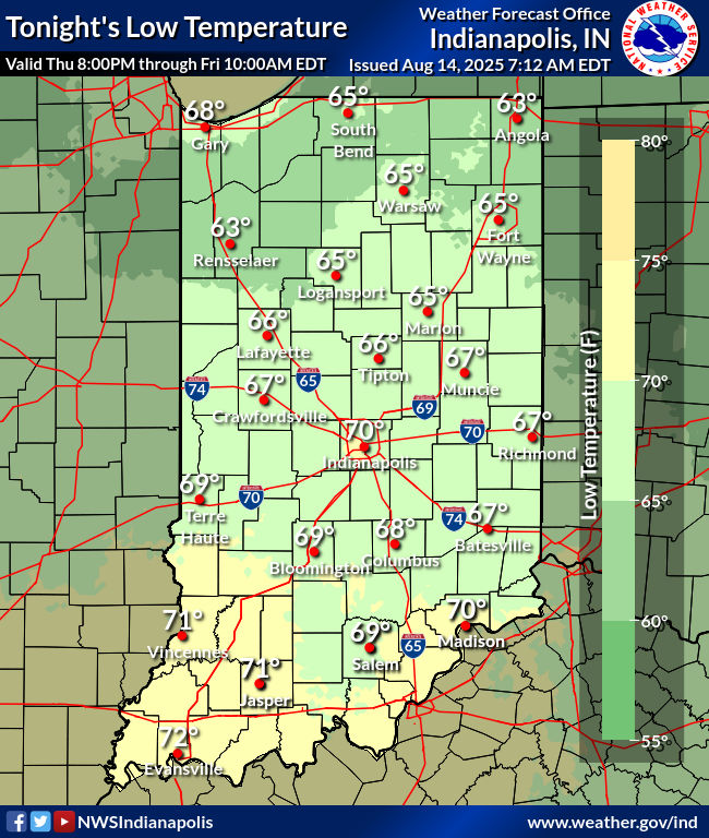
Forecast soundings depict a subsidence inversion with dry air in the
mid-upper levels and deep mixing today which supports a dry
forecast. However, marginal low-level moisture lingering near or
south of I-70 and daytime heating may be just enough to promote a
few stray light showers late. Expected coverage is too low to
include any mentionable POPs. Will keep a very low 10% chance for
precipitation during the afternoon/early evening to account for
this. High resolution models were incorporated to lower dewpoints
this afternoon as blended guidance tends to underestimate diurnal
mixing in these favorable setups.

A weak pressure gradient should keep winds very light. Look for
primarily north/northeasterly flow today with winds veering tonight
as high pressure shifts east. High will range from the mid 80s
across the north to upper 80s south. Overnight temperatures will
fall into the 60s once again thanks to lower dewpoints and
efficient diurnal cooling conditions.

&&

.LONG TERM (Friday through Wednesday)...
Issued at 259 AM EDT Thu Aug 14 2025

Upper level ridging centered over the High Plains will expand east
into the Ohio Valley for the weekend...with a return of a hot and
humid airmass that will reside over the region into the first part
of next week. Uncertainty increases beyond early next week with the
potential for a developing blocky pattern aloft as Erin moves
towards the western Atlantic basin as a hurricane. Confidence
continues to grow however in a more substantial pattern change
locally by Wednesday as the ridge retrogrades into the Intermountain
West...allowing a cold front to surge south bringing an end to the
upcoming heat wave with a much more refreshing airmass arriving for
later next week.

The upper ridging over the central U S will begin its eastward shift
into the Ohio Valley on Friday...bringing multiple days of heat and
humidity that could rival the late July heat wave in terms of temps
and heat indices. Highs will rise into the lower and mid 90s by the
weekend and early next week with dewpoints recovering into the 70s.
Peak heat indices in the afternoons Saturday through Monday will
rise into the 100 to 105 degree range over parts of the forecast
area. A lead upper level wave immediately ahead of the expanding
ridge may carry just enough lift to overcome the developing mid
level cap to generate a stray shower or storm Friday afternoon. As
the core of the ridge centers over the region and the mid level cap
strengthens...convective development will be largely mitigated for
Saturday.

The initial pullback of the mid level heights will begin Sunday and
while the hot and humid air will remain across the Ohio
Valley...there is a touch more uncertainty as to whether far
northern/northeastern portions of the forecast area may be clipped
by any convective complexes riding overtop of the ridge from the
upper Midwest through the Great Lakes and possibly into the Mid
Atlantic region. The subtle weakening of the cap would promote
isolated storms at a minimum limited to peak heating hours of the
afternoon and early evening on Sunday and Monday as well.

Lower than desired confidence in the forecast beginning next Tuesday
through much of the rest of next week. Signs continue to point at
the ridge retrograde by the middle of next week despite the presence
of Erin approaching the Southeast coast. The buckling of mid level
heights would allow for a cold front to push through the Ohio Valley
Tuesday and Wednesday with increasing convective coverage and an end
to the multi-day heat wave upcoming for the weekend and early next
week. Erin remains a wildcard as its location and strength in the
western Atlantic basin next week but there is growing support of a
amplifying upper level trough focused across the Canadian Maritimes
and New England by the middle of next week. This would likely lead
to a recurving tropical system somewhere in the western Atlantic
basin as it is picked up by the trough to the north.
INDY SEVEN DAY FORECAST
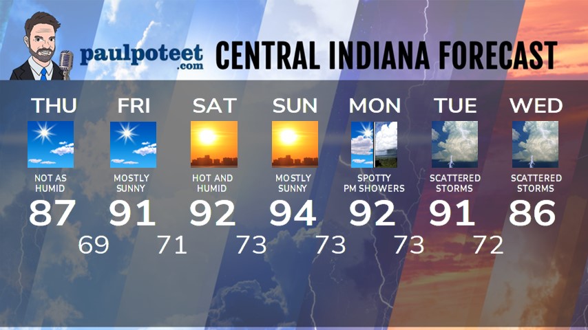
Today: Mostly sunny. Not as humid. High 87.
Tonight: Mostly clear. Low 69.
Friday: Mostly sunny. High 91.
Friday Night: Mostly clear. Humidity increases. Low 71.
Saturday: Mostly sunny. Hot and humid. High 92.
Saturday Night: Mostly clear. Low 73.
Sunday: Mostly sunny. High 94.
Sunday Night: Partly cloudy. Low 73.
Monday: Partly sunny, with spotty afternoon showers and storms. High 92.
Monday Night: Partly cloudy. Low 73.
Tuesday: Partly to mostly cloudy, with scattered showers and storms. High 91.
Tuesday Night: Scattered showers and storms. Low 72.
Wednesday: Partly to mostly cloudy, with scattered showers and storms. High 86.
Never miss me! Subscribe for free. My Huge Radar has real-time weather tracking, current temperatures, and severe weather watches and warnings. Get detailed Indiana conditions by clicking here. Click here to see my central Indiana 7-Day Forecast. Follow these links to get my forecasts for Lafayette, Muncie, Hendricks County, and Hamilton County. Need a second opinion? Click here for central Indiana National Weather Service forecasts. (Some charts via WeatherBELL.)


