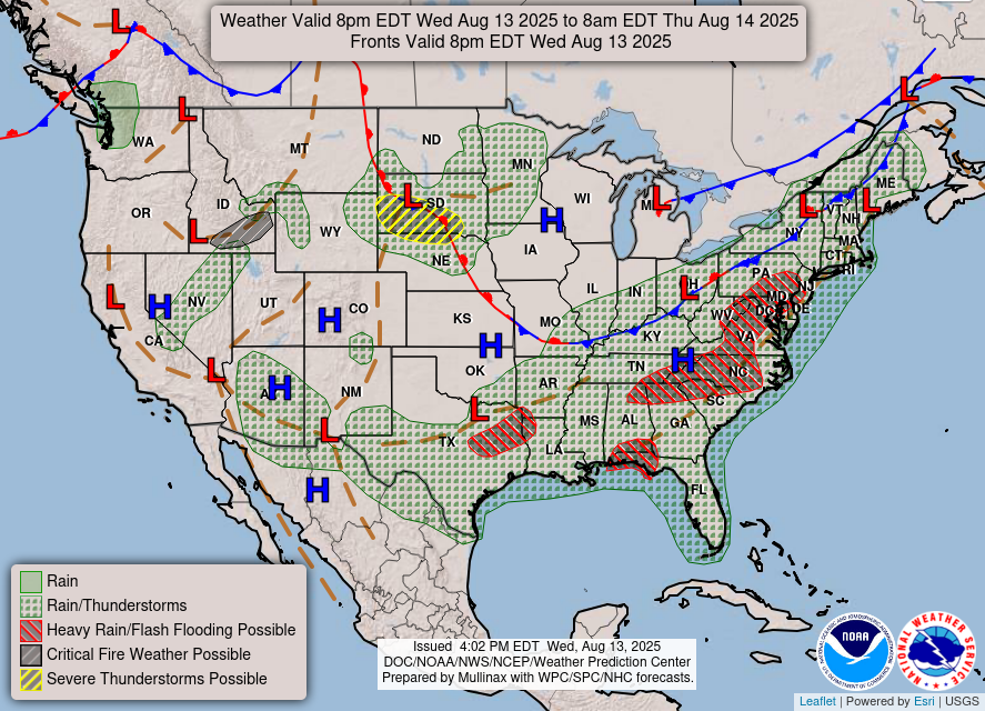
…Scattered flash flooding possible across the Eastern U.S. and Deep
South today…
…Strong to severe thunderstorms forecast for portions of the Northern
Plains this evening and the Upper Midwest tomorrow…
…Heat to shift into the Central High Plains; HeatRisk is forecast to
locally reach Major and locally Extreme level in portion of central
Florida…
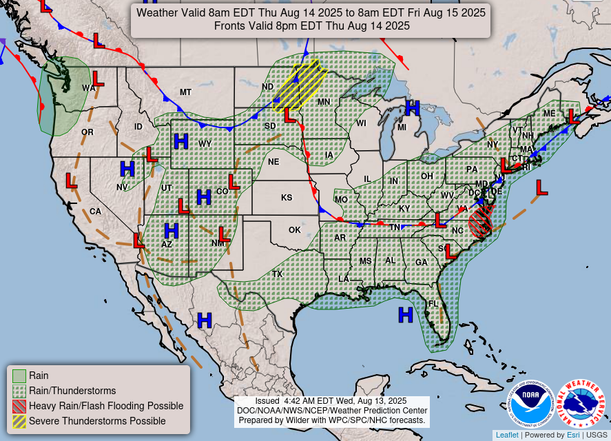
A series of cold fronts forecast to advance from the northwest will
maintain shower and thunderstorm chances across the Eastern and Southern
U.S. to close out the work week. Ahead of these fronts, a large area of
warm and very moist air entrenched across the eastern U.S. and Deep South
will favor periods of very intense hourly rainfall rates within the
stronger cells this afternoon. As such, portions of the Mid-Atlantic
(including the southern half of the I-95 corridor) and Lower Mississippi
Valley have been upgraded to a Slight Risk (Level 2/4) of Excessive
Rainfall today, in addition southern Appalachians and Gulf Coast which
were highlighted overnight. By tomorrow, the southward progression of the
front should usher in a more stable airmass, in turn decreasing
thunderstorm coverage. However, isolated instances of flash flooding
remain possible ahead of the front from the Lower Mississippi Valley into
the Northeast.
Meanwhile, a deepening low pressure system over the Canadian prairies will
drive a warm front across the Northern Plains. Severe thunderstorms are
still forecast to develop near this boundary from South Dakota into
northern Nebraska this evening, where a Slight Risk (level 2/5) of severe
thunderstorms remains in effect, primarily for damaging wind gusts and
isolated large hail. As the warm front advances eastward and then collides
with a cold front pushing in from the Canadian prairies, the severe
weather threat will then head further east across the upper Mississippi
Valley tomorrow into Friday morning.
Cooler temperatures behind this cold front will allow for temperatures to
gradually trend below normal across the northern High Plains and
especially the Northwest U.S. for the latter part of the week. This will
bring a break from the hot weather that portions of the Intermountain West
have been experiencing as well. However, the same hot weather that has
been over the West will shift east into the Central Plains and the Midwest
on Friday. This will bring a couple of days with high temperatures
reaching well into the 90s to the High Plains. Across northern Florida, a
slight increase of heat and humidity is enough to raise HeatRisk into
Major and locally Extreme levels tomorrow and Friday as the Bermuda High
builds westward into the Sunshine State.
Asherman/Kong
Graphics available at
https://www.wpc.ncep.noaa.gov/basicwx/basicwx_ndfd.php