HEADLINES
– More heat and humidity today.
– System brings storm chances Tuesday and Wednesday.
– A little humidity break Wednesday night and Thursday.
– Another hot and humid weekend will follow.
FOLLOWING WEEK
Drier air may finally settle in for a few days!
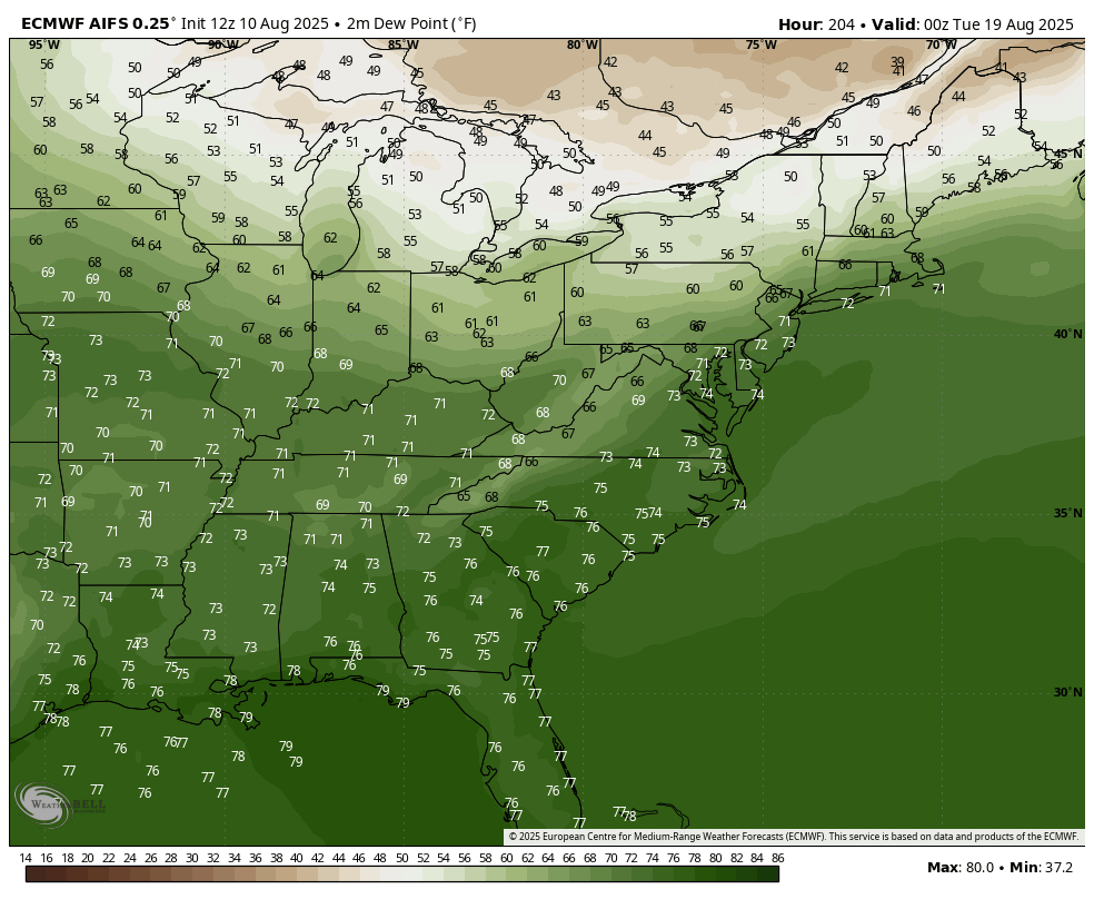
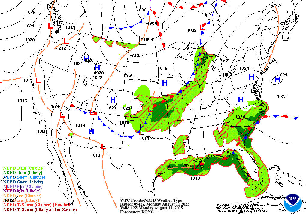
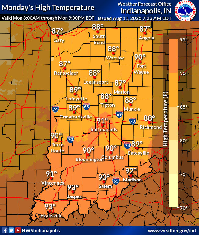
TODAY’S MAP
NWS TECHNICAL DISCUSSION
7
Forecast is in good shape this morning. Another very warm and humid
day is in store, with temperatures already around 80 degrees.

Scattered showers were across northern Illinois and northwest
Indiana, with an isolated shower across northwestern portion of
central Indiana. These were in an area of higher moisture content.

The bulk of showers and storms are expected to remain northwest of
central Indiana, so kept PoPs in the isolated category. Did expand
them a little farther southeast based on current trends seen on
radar.

High temperatures look reasonable given expected conditions so made
no significant changes.

&&

.SHORT TERM (Today and Tonight)...
Issued at 304 AM EDT Mon Aug 11 2025

Steamy conditions early this morning across central Indiana with
already hints of localized fog developing near KBMG. 06Z
temperatures were in the 70s.

The upper level ridging that has been centered over the region
during the last few days has shifted east as the broad upper trough
centered over the northern Plains nudges closer to the Ohio Valley.
Surface ridging remains however which will ensure another day with
hot and humid conditions and a limited risk for convection...but the
deeper moisture that has been held in check to our northwest in
close proximity to a frontal boundary will move a bit closer to the
forecast area. This combined with a weakening of the mid level cap
that has been in place since late last week will at least support a
slightly better threat for convection later today focused
especially across the northern Wabash Valley.

Any fog will be shallow and very localized early this morning and
focused especially over south central Indiana. Once that burns off
after sunrise...mostly sunny skies will give way to diurnal cu
development again by midday. As mentioned above...the lack of a
stronger cap aloft should enable a more extensive cu field for the
afternoon that has more vertical depth to it as well. With modest
instability levels again...isolated convection will develop during
the afternoon and early evening but overall coverage is once again
likely to be lower than 15% for most of central Indiana and
consequently below the thresholds for including in the forecast.

The one exception will be over the northwest portions of the
forecast area where deeper moisture will advect into the area
evidenced by PWATs rising to near 1.5 inches if not slightly higher.
With the potential for remnant outflow boundaries from storms
further west migrating into the northern Wabash Valley as well...
low precip chances are warranted here but will confine to areas
generally northwest of a Covington to Kokomo line into the early
evening. Storms will be sluggish movers pulsing in intensity in the
absence of much in the way of BL shear. The thermodynamic profiles
support localized gusty winds with any collapsing downdraft with
stronger cells but as has been the case with convection over the
last few weeks...heavy rainfall will be the primary impact from any
showers and storms.

Convection will diminish with sunset and refocus closer to the
primary frontal boundary extending from the lower Great Lakes into
northern Missouri. Anticipate more cloud debris over the region with
the boundary and convection along it closer to the forecast area but
overall it should be a quiet yet muggy night.

Temps...low level thermals are supportive of highs peaking in the low
90s again this afternoon with heat indices climbing into the mid
90s. Lows tonight will hover around 70 once again.

&&

.LONG TERM (Tuesday through Sunday)...
Issued at 304 AM EDT Mon Aug 11 2025

Generally hot and humid conditions will be the rule through the long
term period...although a modest respite should grace most of the
region through a couple mid-week periods, as central Indiana catches
the southern extents of high pressure crossing the Great
Lakes/Ontario.  Isolated to scattered convection is expected Tuesday-
Wednesday from a tilting, yet lifting northern short wave and its
corresponding slowly approaching cool front.  Best chances for any
organized, likely non-severe cells, and isolated downpours would be
in the late Tuesday timeframe...when the antecedent axis of greater
precipitable water glides over the CWA.  More of this summer`s ample
instability, but low shear may allow a few strong cells amid the
ordinary convection.

The Wednesday night to Thursday night timeframe will bring a subtle
taste of late August to at least northern zones where low to mid-60s
dewpoints can be expected from the slowly passing surface ridge
whose center will stay well to the north of Indiana.  Otherwise the
period will feature dewpoints in/near the low 70s courtesy of light,
mainly southerly breezes.  Despite the persistent humidity, mainly
dry conditions will return Wednesday night, although a stray shower/
t-storm cannot be ruled out through Thursday afternoon south of I-70
amid the lingering boundary/frontal zone.  Rain-free conditions will
be the rule for the rest of the period as the very broad subtropical
upper ridge pushes any forcing well north of the region.

Heat and heat indices will be consistently above normal, yet below
Advisory criteria.  Excepting widespread 80s Wednesday and
especially Thursday...upper 80s/low 90s afternoon maxs are expected.
When combined with higher dewpoints...mid- to upper-90s maximum heat
index values are expected for most zones on Tuesday...and Friday and
onward.  The period`s highest heat index values will most likely
occur this upcoming weekend. The normal max/min at Indianapolis
through August 14 is 85/66.
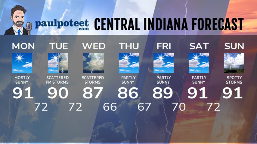
INDY SEVEN DAY FORECAST
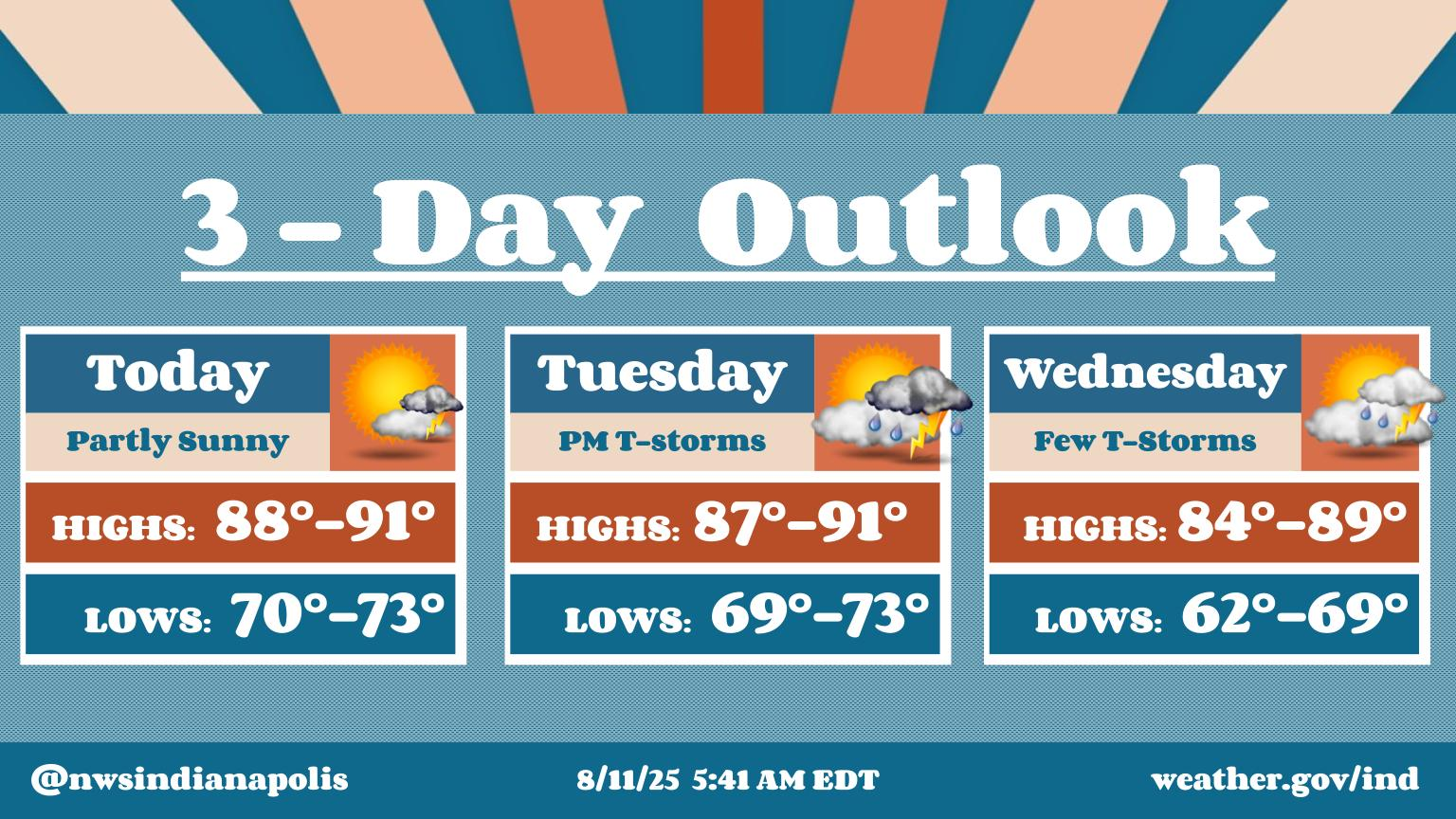
Today: Mostly to partly sunny. Hot and humid. High 91.
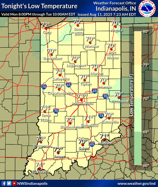
Tonight: Mostly clear. Low 72.
Tuesay: Partly sunny. Scattered showers and storms by afternoon. High 90.
Tuesday Night: Scattered showers and storms. Low 72.
Wednesday: Partly to mostly cloudy, with spotty showers and scattered afternoon storms. High 87.
Wednesday Night: Scattered storms end in the early evening. Partly cloudy. Low 66.
Thursday: Partly sunny. High 86.
Thursday Night: Partly cloudy. Low 67.
Friday: Partly sunny. High 89.
Friday Night: Partly cloudy. Low 70.
Saturday: Partly sunny. High 91.
Saturday Night: Partly cloudy. Storm chances overnight. Low 72.
Sunday: Partly sunny. Scattered showers and storms. High 91.
Never miss me! Subscribe for free. My Huge Radar has real-time weather tracking, current temperatures, and severe weather watches and warnings. Get detailed Indiana conditions by clicking here. Click here to see my central Indiana 7-Day Forecast. Follow these links to get my forecasts for Lafayette, Muncie, Hendricks County, and Hamilton County. Need a second opinion? Click here for central Indiana National Weather Service forecasts. (Some charts via WeatherBELL.)


