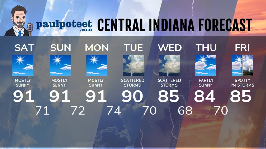
HEADLINES
– Status Quo today and tomorrow.
– Storm chances Tuesday and Wednesday.
– Long term trend: still above average through *next* weekend.
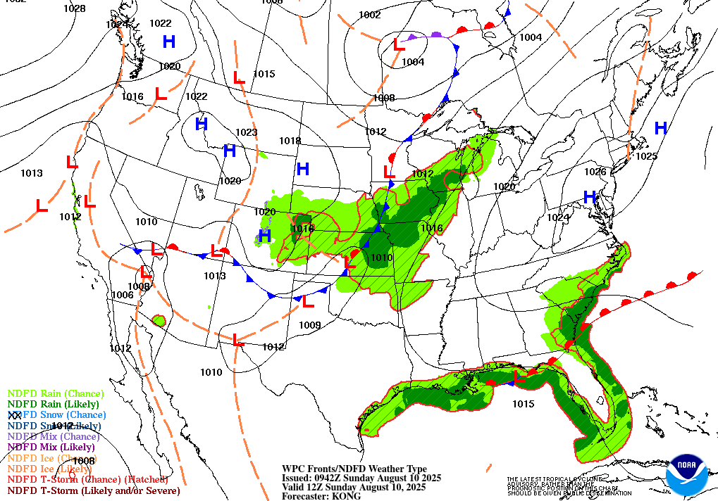
TODAY’S MAP
NWS TECHNICAL DISCUSSION
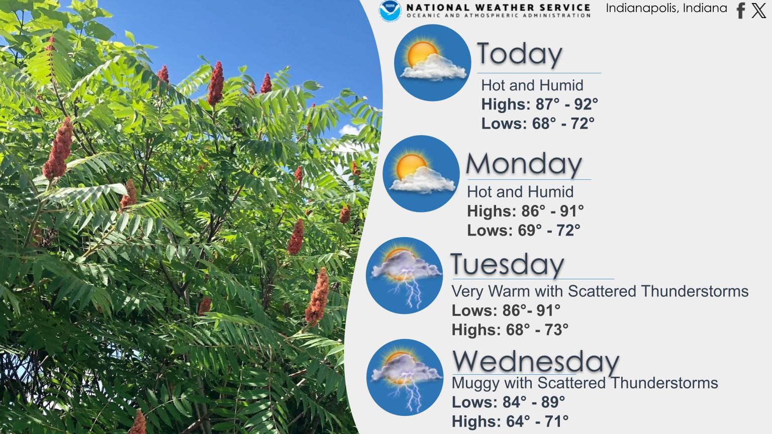
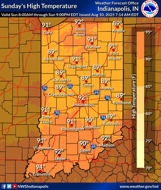
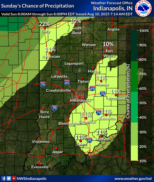
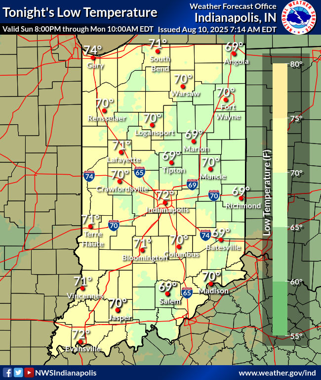
Clear skies and light winds again early this morning as central
indiana resides under ridging aloft and at the surface. An area of
mid and high level clouds was closing in on the northern Wabash
valley as deep convection organizes from the central Plains
northeast into the western Great Lakes. 06Z temperatures were in the
70s.

The ongoing expansion of the aforementioned convection to our
northwest which appears to be trending towards multiple clusters
coalescing into a broad complex that extends from Kansas and
Nebraska northeast to Lake Michigan will persist throughout the
predawn hours and likely past daybreak. The ridging aloft and well
defined subsidence downwind across the Ohio Valley however will not
enable the frontal boundary or the convection growing in its
vicinity to make much of an eastward progression through the short
term.

The area of mid and high clouds over northern Illinois may drift
briefly into the northern Wabash Valley over the next few hours but
that will likely be about it as an abundance of dry air remains
overhead. Fog is not out of the question through daybreak but should
remain localized and brief.

With mid level heights maximized across the region...expect another
hot and humid day with any convection remaining isolated at best and
fully dependent on the modest instability present as MLCAPEs peak
near 3000 j/kg by the afternoon despite the lingering mid level cap.
If any location within the forecast area stands a chance to see a
stray shower or storm...it appears to be across the southeast half
of the forecast area where slightly better moisture exists. Still
though...overall convective coverage will probably cap at 10% at its
peak which is not enough to place in the forecast at this point.
Scattered cu developing during the afternoon will diminish towards
sunset with another quiet but muggy night for tonight.

Temps...highs will be similar to Saturday within a couple degrees
either side of 90. Lows tonight will be around 70.

&&

.LONG TERM (Monday through Saturday)...
Issued at 234 AM EDT Sun Aug 10 2025

Continued warm and humid conditions will begin the work week
as ridging aloft resides across the Ohio Valley. A sluggish moving
upper level trough entered across the northern Plains will help to
flatten the ridge and briefly bring a lowering of mid level heights
further south by Tuesday and Wednesday along with a frontal boundary
that will reintroduce scattered convection into the region. The
front will stall out and steadily weaken but linger across the Ohio
Valley through late week with daily chances for thunderstorms
persisting but slowly decreasing in coverage. The warm and humid
airmass will remain with the potential for slightly warmer air to
return by next weekend as the upper ridge flexes back into the
region form the southwest.

Monday through Thursday Night

The ridging at the surface and aloft will remain the primary
influence across central Indiana on Monday while keeping a frontal
boundary locked in place to the northwest of the area. Model
soundings show the mid level cap that has been present through the
weekend will be much weaker but warmer air aloft will remain and
virtually no shear will be present under the ridge. Convection will
be fully reliant on the modest instability available which will
limit coverage significantly but likely be sufficient to generate
a few stray showers or storms during the afternoon and early evening.

As the upper trough finally progresses further southeast into the
region on Tuesday and Wednesday...expect a greater threat for
thunderstorms with the additional influence of the frontal boundary
drifting south into the region. The main convective risks will be
heavy rainfall and localized flooding as a lack of substantial shear
will ensure slow movement to storms that will pulse up and down in
intensity. There is always the potential for a cell to strengthen
enough briefly to produce localized downbursts as the cores collapse
but that is likely to remain a secondary concern throughout late
week. Heights aloft will begin to rise on Thursday as the upper
level trough moves away into New England. Isolated to scattered
convection will again be possible within the moist and unstable
airmass across the Ohio Valley.

Highs will be near 90 degrees both MOnday and Tuesday but the
potential for increased cloud cover by Wednesday will lead to
slightly cooler temps for Wednesday and Thursday primarily in the
mid 80s.

Friday through Saturday

The ridge will expand back northeast towards the Ohio Valley into
the weekend with temperatures returning to around 90 degrees for
highs. The muggy airmass will remain all week and feel even more
oppressive by Saturday and Sunday with the return of hotter
temperatures. With dewpoints in the lower 70s...peak heat indices
will likely approach 100 degrees next weekend. The return of upper
level ridging and warmer air aloft will trend towards less threats
for convection by next weekend with coverage likely to be isolated
at best and limited to peak heating hours of the afternoon and early
evening.

Signs continue to increase in little to no change in the
pattern for next week beyond the 7 day period into the following
week as cooler and drier air remains bottled up well to the north of
central Indiana.
Never miss me! Subscribe for free. My Huge Radar has real-time weather tracking, current temperatures, and severe weather watches and warnings. Get detailed Indiana conditions by clicking here. Click here to see my central Indiana 7-Day Forecast. Follow these links to get my forecasts for Lafayette, Muncie, Hendricks County, and Hamilton County. Need a second opinion? Click here for central Indiana National Weather Service forecasts. (Some charts via WeatherBELL.)


