HEADLINES
– Quieter weather continues, with a gradual increase in heat and humidity.
– Isolated late afternoon and evening storms. Better chances Tuesday afternoon.
– No big rain amounts, nothing severe, no tropical humidity and no 90s this week!
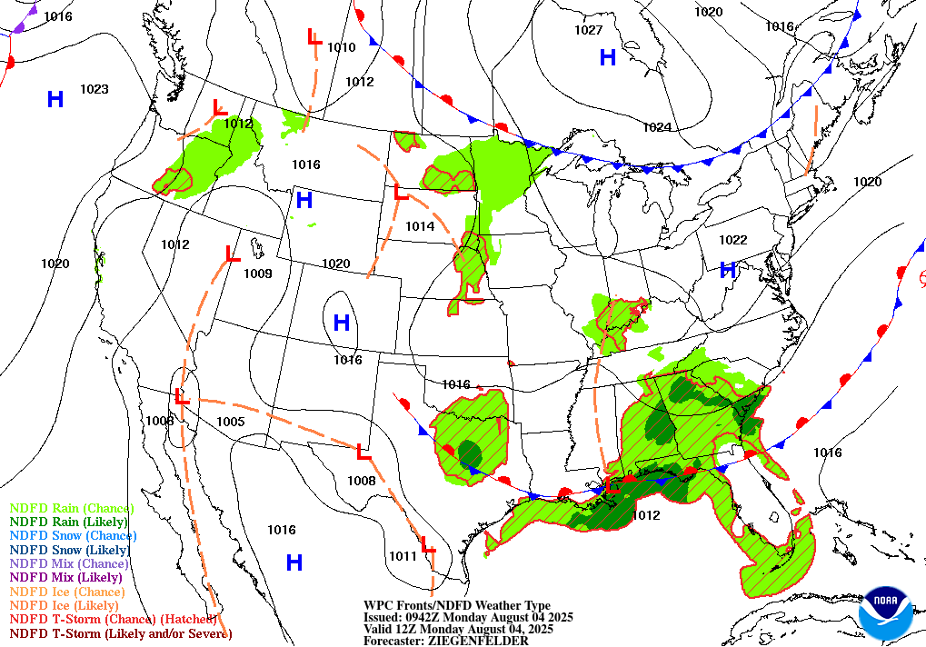
TODAY’S MAP
NWS TECHNICAL DISCUSSION
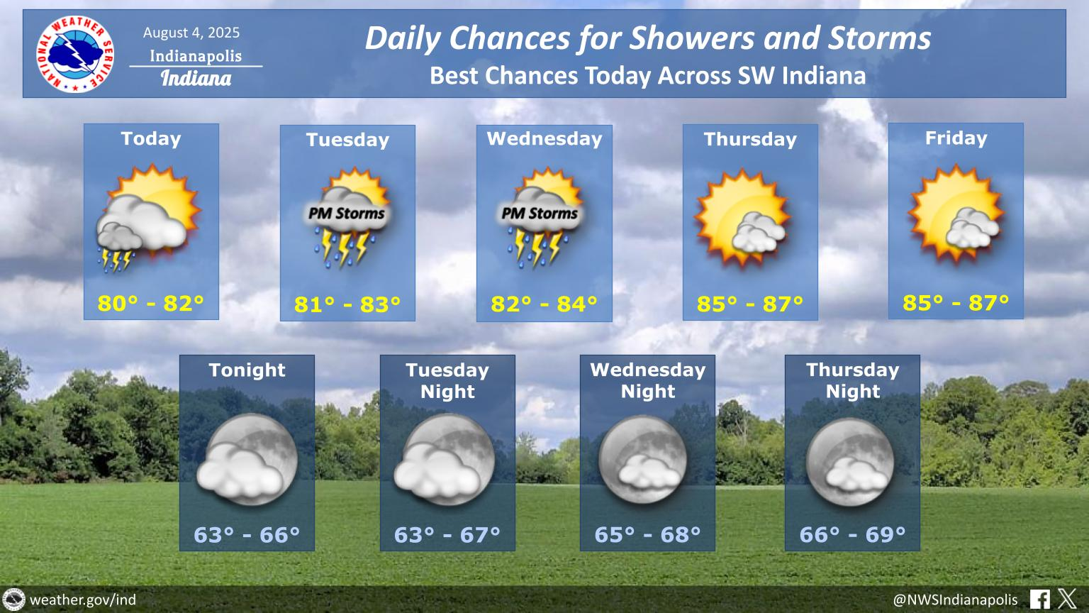
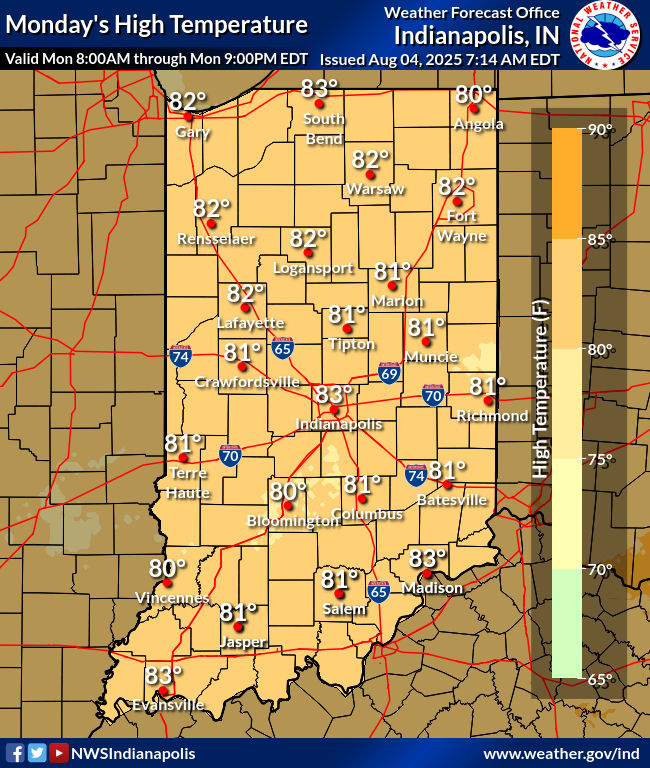
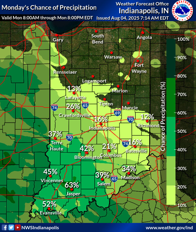
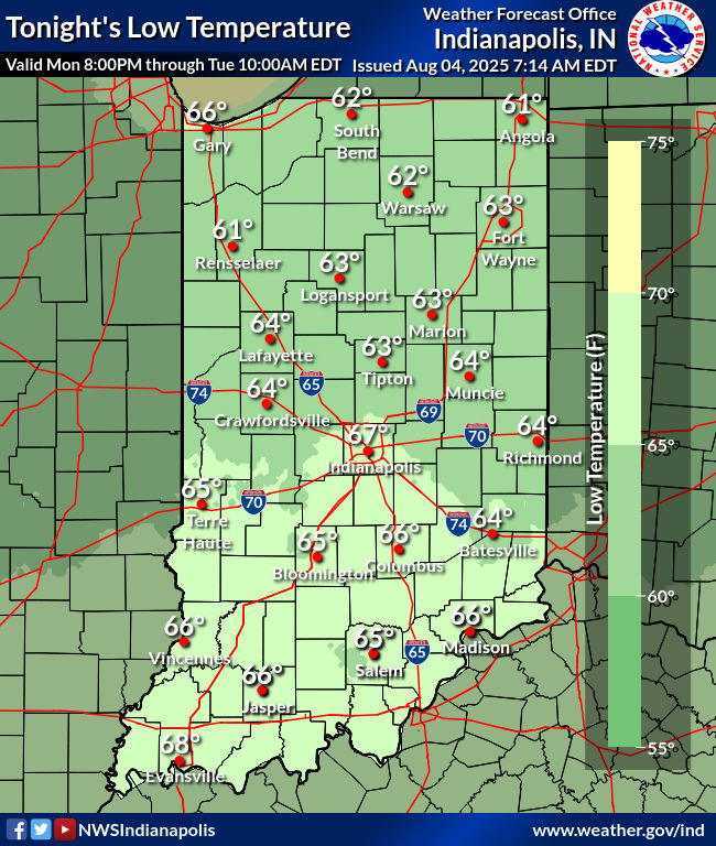
Main focus for the short term period today will be tracking an
inverted trough with some tropical influences and how it is
expected to bring isolated to scattered showers and thunderstorms to
portions of southern Indiana. As of early this morning, coverage in
showers is limited to just the far southern portions of the state,
but expect to see at least a few showers towards Vincennes and
Bedford towards daybreak. By mid-afternoon diurnal heating will
allow for 1000-15000 J/kg of CAPE. This instability combined with
forcing associated with the trough to bring increased coverage in
showers and better chances for rumbles of thunder.

Primary concerns with these showers and storms will be localized
flooding due to heavy rain rates and slow storm motion. Areas to
the north and east of Indianapolis should remain dry today with
model soundings showing a lack of the deeper moisture as compared
to areas closer to Vincennes. Temperatures will remain cooler than
normal today with expected highs in the low 80s but as low level
moisture advects into the area, dew points in the low to mid 60s
will become more widespread towards the evening.

Tonight.

As diurnal heating comes to an end shower coverage should gradually
decrease through the night but with the trough in the vicinity, at
least a few showers should continue through much of the night
especially as models continue to show moisture advection in the
lower levels. The increased near surface moisture will keep
temperatures more mild tonight with expected lows in the mid 60s.

&&

.LONG TERM (Tuesday through Sunday)...
Issued at 131 AM EDT Mon Aug 4 2025

Tuesday Through Thursday.

A similar pattern will continue Tuesday into Wednesday with the
aforementioned trough stalling across the lower Ohio Valley which
will bring daily chances for showers and storms through Wednesday,
mainly across the southwestern counties but with coverage increasing
towards central and north central Indiana. Highs will also gradually
warm through the week as the surface flow gains a slightly more
southerly component with highs in the mid 80s by Wednesday. The
trough will become more diffuse on Thursday which coincides with the
ridge to the west gradually building eastward and helping push the
jet stream further north into Canada. This will help to limit the
rain chances Thursday other than a stray diurnally induced
thunderstorm.

Friday Through Sunday.

Hot and humid conditions expected Friday into the weekend with model
soundings showing convective temperatures likely to be reached which
combined with a lack of warmer air aloft to allow for diurnally
driven convection each afternoon. Daily highs should climb into the
upper 80s to near 90 with dew points in the low 70s. These will
combine to bring elevated heat risk with peak heat index values in
the mid to upper 90s, but without the richer surface moisture that
was seen last week, heat headlines look unlikely at this time.
Looking into early next week, a frontal system looks to move through
bringing better chances for rain before stalling and leading to a
period of hot and humid conditions through much of the week.
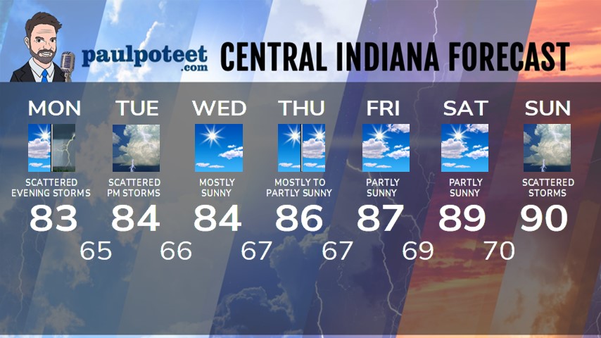
INDY SEVEN DAY FORECAST
Today: Partly to mostly cloudy. An isolated shower or storm is possible in the late afternoon. High 83.
Tonight: Clouds increase, with spotty showers and storms, especially overnight. Low 65.
Tuesday: Partly sunny. Scattered showers and storms in the afternoon. High 84.
Tuesday: Spotty evening showers and storms. Low 66.
Wednesday: Mostly sunny. High 84.
Wednesday Night: Mostly clear. Low 67.
Thursday: Mostly to partly sunny. High 86.
Thursday Night: Partly cloudy. Low 67.
Friday: Partly sunny. Humidity becomes more tropical again. High 87.
Friday Night: Partly cloudy. Low 69.
Saturday: Partly sunny. High 89.
Saturday Night: Partly cloudy. Low 70.
Sunday: Partly to mostly cloudy. Scattered showers and storms. High 90.
Never miss me! Subscribe for free. My Huge Radar has real-time weather tracking, current temperatures, and severe weather watches and warnings. Get detailed Indiana conditions by clicking here. Click here to see my central Indiana 7-Day Forecast. Follow these links to get my forecasts for Lafayette, Muncie, Hendricks County, and Hamilton County. Need a second opinion? Click here for central Indiana National Weather Service forecasts. (Some charts via WeatherBELL.)


