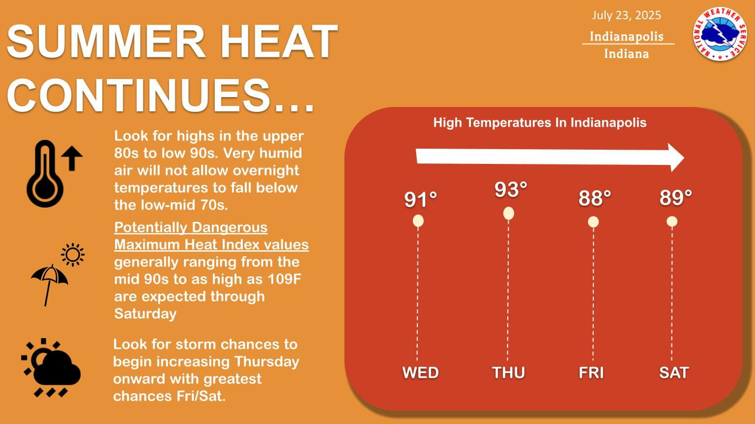
HEADLINES
– Heat Advisory for west central Indiana this afternoon through Thursday.
– Advisory for the rest of the state begins tomorrow.
– Dangerous heat continues through early next week. Heat indices: 100-105.
– Storm chances return as early as Thursday and persist throughout the weekend.
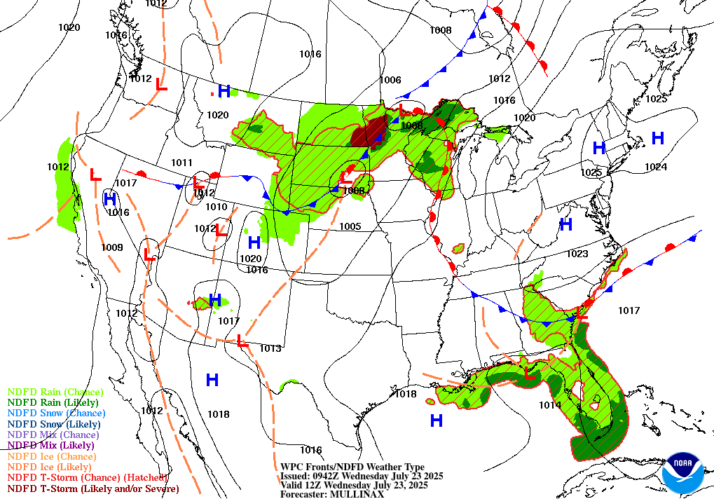
TODAY’S MAP
NWS TECHNICAL DISCUSSION
Upper level ridging will continue to dominate the area through the
short term, though the ridge will broaden and flatten a bit as we
move into Thursday. This, coupled with the approach of a weak
surface front and subtle upper level impulses moving in the
southwesterly flow aloft may allow isolated thunderstorms to develop
as early as Thursday afternoon across central Indiana.

HEAT AND HUMIDITY -

Quiet, but hot and humid, weather is expected across central Indiana
today, with highs in the upper 80s to low 90s, and dewpoints
steadily increasing through the day as surface flow veers back to
the south.

The combination of hot temperatures and dewpoints rising into the
mid 70s across the western third of central Indiana will push peak
heat index values to near or above advisory criteria of 105, thus
will continue the Heat Advisory there.

Additionally, with overnight lows struggling to get much below the
mid 70s, offering little relief, followed by slightly hotter highs
and dewpoints as high as the mid to upper 70s, have extended this
western segment of the Heat Advisory through Thursday.

The remainder of central Indiana will see dewpoints well into the
mid 70s by late morning Thursday, bringing afternoon heat index
values to near or above criteria as well, and have expanded the
advisory to encompass the entire area on Thursday as a result.

THUNDERSTORM THREAT -

Despite a hot and increasingly humid airmass, a lack of any
significant forcing mechanism and capping aloft (700 mb temps of 11-
12C) should prevent deep, moist convection today.

However, a weak frontal boundary begins to approach from the
northwest Thursday, and despite continued though substantially
weaker capping, this along with weak forcing for ascent from subtle
upper level impulses skirting the area in the southwesterly flow
aloft may allow isolated thunderstorms to develop during the
afternoon hours, and will maintain a 20 PoP as a result.

While bulk shear will be weak to modest at best, strong to extreme
instability values, along with a midlevel dry intrusion centered
around 650 mb, may be able to produce a strong storm or two with
strong, perhaps damaging downburst winds. Any storm will be capable
of producing heavy rainfall and localized flooding given recent
locally heavy rains and precipitable water values nearing 90th
percentile climatologically.

&&

.LONG TERM (Thursday Night through Tuesday)...
Issued at 304 AM EDT Wed Jul 23 2025

Thursday night through Saturday night...

Hot and humid conditions will persist through much of the extended
period along with daily chances for storms. Aloft, model guidance
depicts an upper ridge centered over the eastern CONUS at the start
of the period. The upper ridge should then gradually retrograde into
early or middle of next week resulting in northwesterly flow aloft .

Strengthening southwesterly flow ahead of an approaching boundary
will help to pull in deeper moisture for precipitation late Thursday
into Friday. Expect increasing rain chances as the boundary moving
in from the N/NW provides low-level convergence for convective
development. Most guidance is in good agreement showing the boundary
stalling near the area once mean flow becomes parallel to it on
Friday. This combined with deep-moisture and strong daytime heating
keeps daily chances for showers or storms in the forecast.

The greatest precipitation chances at this time are Thursday night
through late Saturday before the boundary becomes diffuse and washes
out. Hot/humid conditions promoting strong instability and
potentially steep low-level lapse rates at times could support a few
strong to severe storms during the period. The primary threats are
isolated damaging wind gusts and localized flooding.

Sunday through Tuesday...

The retrograding upper ridge will become centered over the central
CONUS by early next week resulting in northwesterly flow aloft. With
central Indiana remaining on the northern or northeastern periphery
of the ridge, there could be ridge riders which promote convection
at times. Exact details on these features are more difficult to
discern compared to a synoptic system or boundary so look for lower
POPs during this period due to limited confidence. Refinements will
be made to the forecast as details become clearer.

Look for hot and humid conditions to persist. Peak heat indices are
generally expected to range from near 100 to as high as 108F in a
few locations. Long range guidance suggest there could be some
relief beyond Tuesday with ensembles depicting upper troughing and
cooler/drier air overspreading the eastern CONUS mid-late next week.
This will continue to be monitored because we could certainly use a
break from the miserable heat coming up.
INDY SEVEN DAY FORECAST
Today: Mostly sunny. High 86.
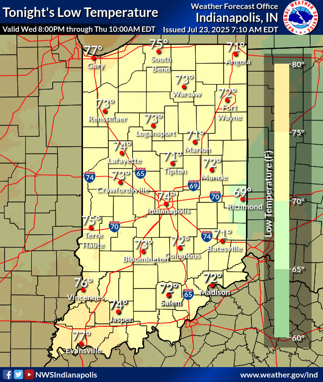
Tonight: Mostly clear. Low 65.
Wednesday: Mostly sunny. Humidity increases. High 91.
Wednesday Night: Mostly clear. Low 72.
Thursday: Partly sunny. High 93.
Thursday Night: Partly cloudy. Low 75.
Friday: Partly sunny. Scattered showers and storms. High 90.
Friday Night: Partly cloudy. Scattered showers and storms. Low 73.
Saturday: Partly sunny. Scattered showers and storms. High 88.
Saturday Night: Partly cloudy. Low 73.
Sunday: Partly sunny. Spotty showers and storms. High 90.
Sunday Night: Partly cloudy. Low 73.
Monday: Mostly sunny. High 91.


Never miss me! Subscribe for free. My Huge Radar has real-time weather tracking, current temperatures, and severe weather watches and warnings. Get detailed Indiana conditions by clicking here. Click here to see my central Indiana 7-Day Forecast. Follow these links to get my forecasts for Lafayette, Muncie, Hendricks County, and Hamilton County. Need a second opinion? Click here for central Indiana National Weather Service forecasts. (Some charts via WeatherBELL.)


