…There is a Slight Risk of excessive rainfall over parts of the
Southeast on Friday/Saturday and the Central/Southern Rockies on
Saturday…
…There are Extreme Heat Warnings and Heat Advisories along the West
Coast and just inland…
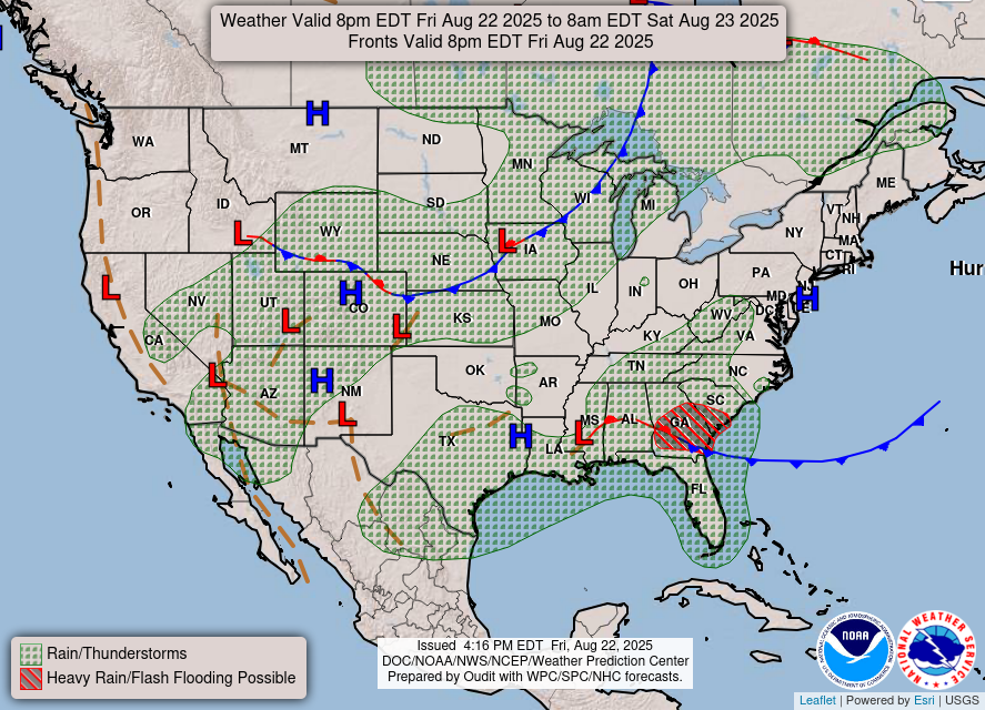
A front extending from the Upper/Middle Mississippi Valley southwestward
to the Central Plains/Central Rockies on Friday will advance eastward to
the Lower Great Lakes to the Tennessee Valley/Southern Plains by Sunday.
The front will produce showers and thunderstorms from the Upper Great
Lakes to the Middle Mississippi Valley on Friday, over parts of the Great
Lakes on Saturday, and the Lower Great Lakes/Northeast into the Central
Appalachians on Sunday.
A second front over the Southeast will linger through Sunday morning. The
southern boundary will ignite showers and thunderstorms over the Southeast
and along most of the Gulf Coast, with heavy rain over the Southeast
through Saturday. Therefore, the WPC has issued a Slight Risk (level 2/4)
of excessive rainfall over the Southeast from Friday into Saturday morning
and from Saturday into Sunday. The associated heavy rain will create
mainly localized areas of flash flooding, with urban areas, roads, small
streams, and low-lying areas the most vulnerable.
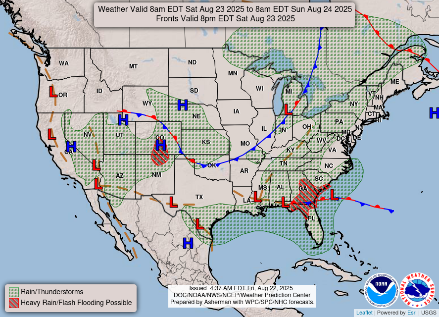
In addition, monsoonal moisture, diurnal heating, and upper-level impulses
will produce showers and thunderstorms over southeastern California, the
Southwest, the Great Basin, the Central/Southern Rockies, and the Central
High Plains from Friday into Sunday. Heavy rain will develop over parts of
the Central/Southern Rockies on Saturday. Therefore, the WPC has issued a
Slight Risk (level 2/4) of excessive rainfall over the Central/Southern
Rockies from Saturday into Sunday morning. The associated heavy rain will
create mainly localized areas of flash flooding, with urban areas, roads,
small streams, and low-lying areas the most vulnerable.
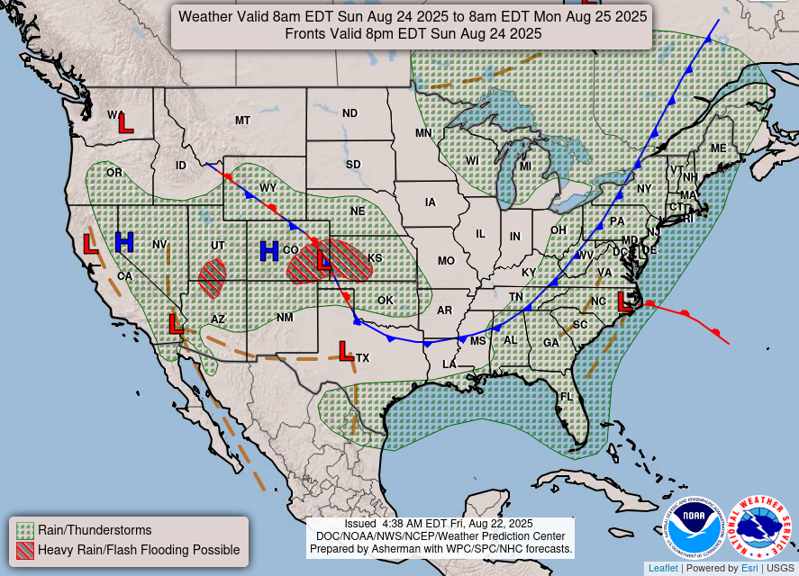
Showers and thunderstorms will continue over parts of the Great Basin and
into the Central Plains on Sunday. Heavy rain will develop over parts of
the Central Plains/Central Rockies, as well as a second area over the
Great Basin/Southwest. Therefore, the WPC has issued a Slight Risk (level
2/4) of excessive rainfall over the Central Plains/Central Rockies from
Saturday into Sunday morning and the Great Basin/Southwest from Sunday
into Monday morning. The associated heavy rain will create mainly
localized areas of flash flooding, with urban areas, roads, small streams,
and low-lying areas the most vulnerable.
Meanwhile, an upper-level high over the Southwest into the
Central/Southern Rockies will aid in creating a heat wave across much of
the Western U.S. through the weekend, with the most intense and
long-lasting heat across the Desert Southwest into the San Joaquin Valley.
Extreme Heat Warnings and Watches are in effect from portions of Arizona
through Washington State. This type of heat will be dangerous, posing a
threat to anyone without effective cooling and adequate hydration.
Numerous daily high temperature records are likely to be broken. For many
areas, there will be little nighttime relief from the extreme heat, with
overnight lows remaining well above normal. Numerous nighttime temperature
records are likely. Extreme heat is dangerous even at night when
temperatures don�t cool down. Without A/C or cooling, the body can�t
recover, increasing the risk of heat illness.
Stay informed and take steps to protect yourself from heat-related
illnesses. For information on staying cool and safe, visit
www.weather.gov/safety/heat. As temperatures rise, limit outdoor activity,
stay hydrated, and ensure access to air-conditioning and other cooling
areas.
Ziegenfelder
Graphics available at
https://www.wpc.ncep.noaa.gov/basicwx/basicwx_ndfd.php