718
WWUS83 KIND 170508
SPSIND
Special Weather Statement
National Weather Service Indianapolis IN
108 AM EDT Sun Aug 17 2025
INZ043-044-051-170600-
Parke IN-Vermillion IN-Vigo IN-
108 AM EDT Sun Aug 17 2025
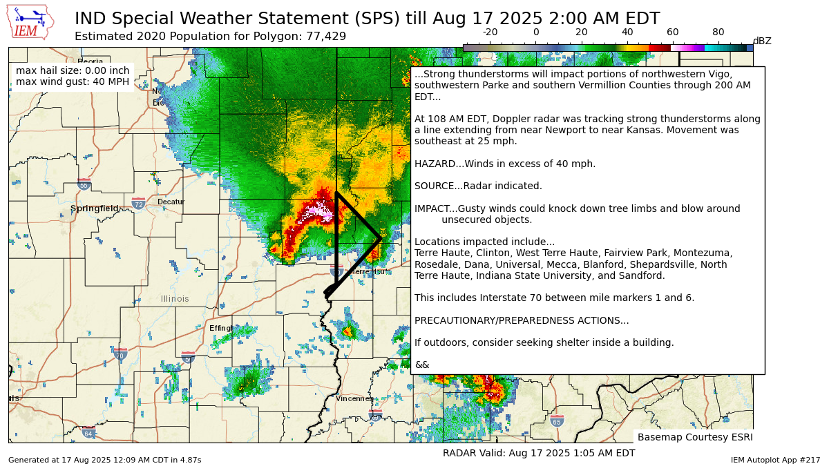
...Strong thunderstorms will impact portions of northwestern Vigo,
southwestern Parke and southern Vermillion Counties through 200 AM
EDT...
At 108 AM EDT, Doppler radar was tracking strong thunderstorms along
a line extending from near Newport to near Kansas. Movement was
southeast at 25 mph.
HAZARD...Winds in excess of 40 mph.
SOURCE...Radar indicated.
IMPACT...Gusty winds could knock down tree limbs and blow around
unsecured objects.
Locations impacted include...
Terre Haute, Clinton, West Terre Haute, Fairview Park, Montezuma,
Rosedale, Dana, Universal, Mecca, Blanford, Shepardsville, North
Terre Haute, Indiana State University, and Sandford.
This includes Interstate 70 between mile markers 1 and 6.
PRECAUTIONARY/PREPAREDNESS ACTIONS...
If outdoors, consider seeking shelter inside a building.
&&
LAT...LON 3934 8758 3936 8753 3992 8753 3964 8718
3928 8761 3930 8760 3931 8762
TIME...MOT...LOC 0508Z 328DEG 21KT 3987 8747 3951 8788
MAX HAIL SIZE...0.00 IN
MAX WIND GUST...40 MPH
$$
GM
https://mesonet.agron.iastate.edu/p.php?pid=202508170508-KIND-WWUS83-SPSIND
Warnings always on My Huge Radar!
Never miss me! Subscribe for free. My Huge Radar has real-time weather tracking, current temperatures, and severe weather watches and warnings. Get detailed Indiana conditions by clicking here. Click here to see my central Indiana 7-Day Forecast. Follow these links to get my forecasts for Lafayette, Muncie, Hendricks County, and Hamilton County. Need a second opinion? Click here for central Indiana National Weather Service forecasts. (Some charts via WeatherBELL.)


