HEADLINES
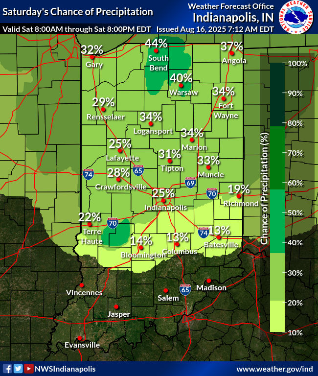
– Increasing chances for storms this weekend, especially along and north of I-70.
– Isolated strong to severe storms with strong winds are possible, along with locally heavy rain.
– Hot and humid through Tuesday.
– Greater threat for storms Tuesday and Wednesday with a cold front. Cooler and drier air golloed.
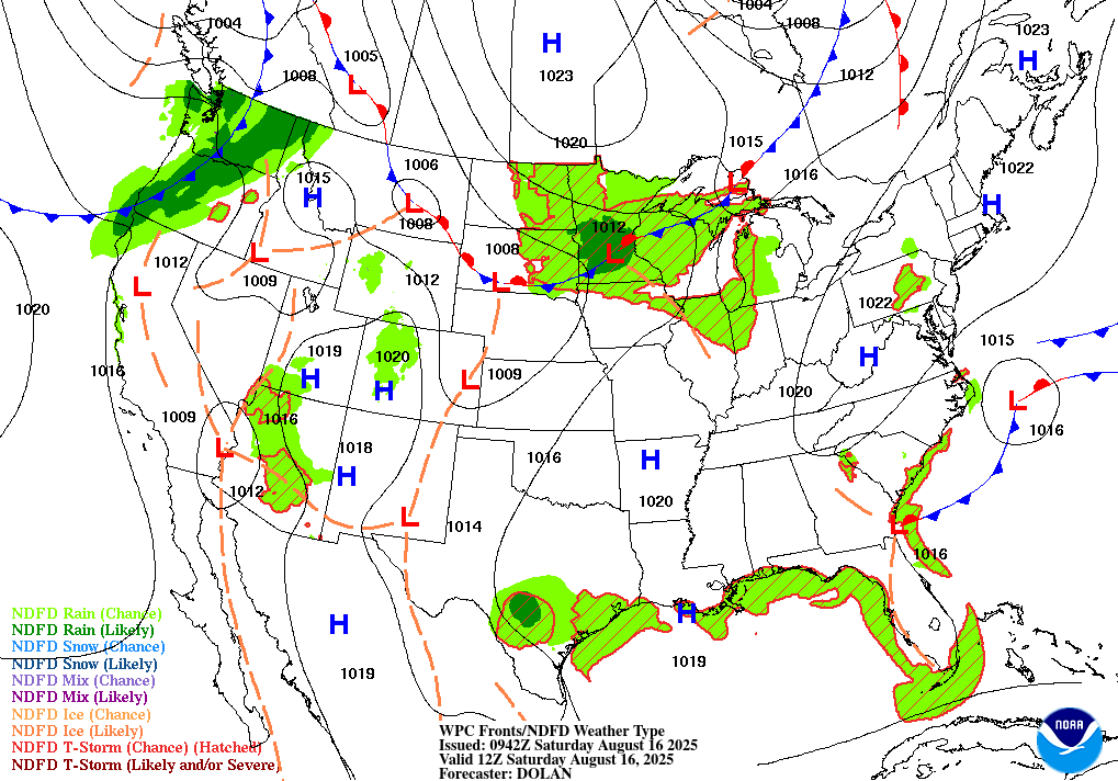
TODAY’S MAP
NWS TECHNICAL DISCUSSION
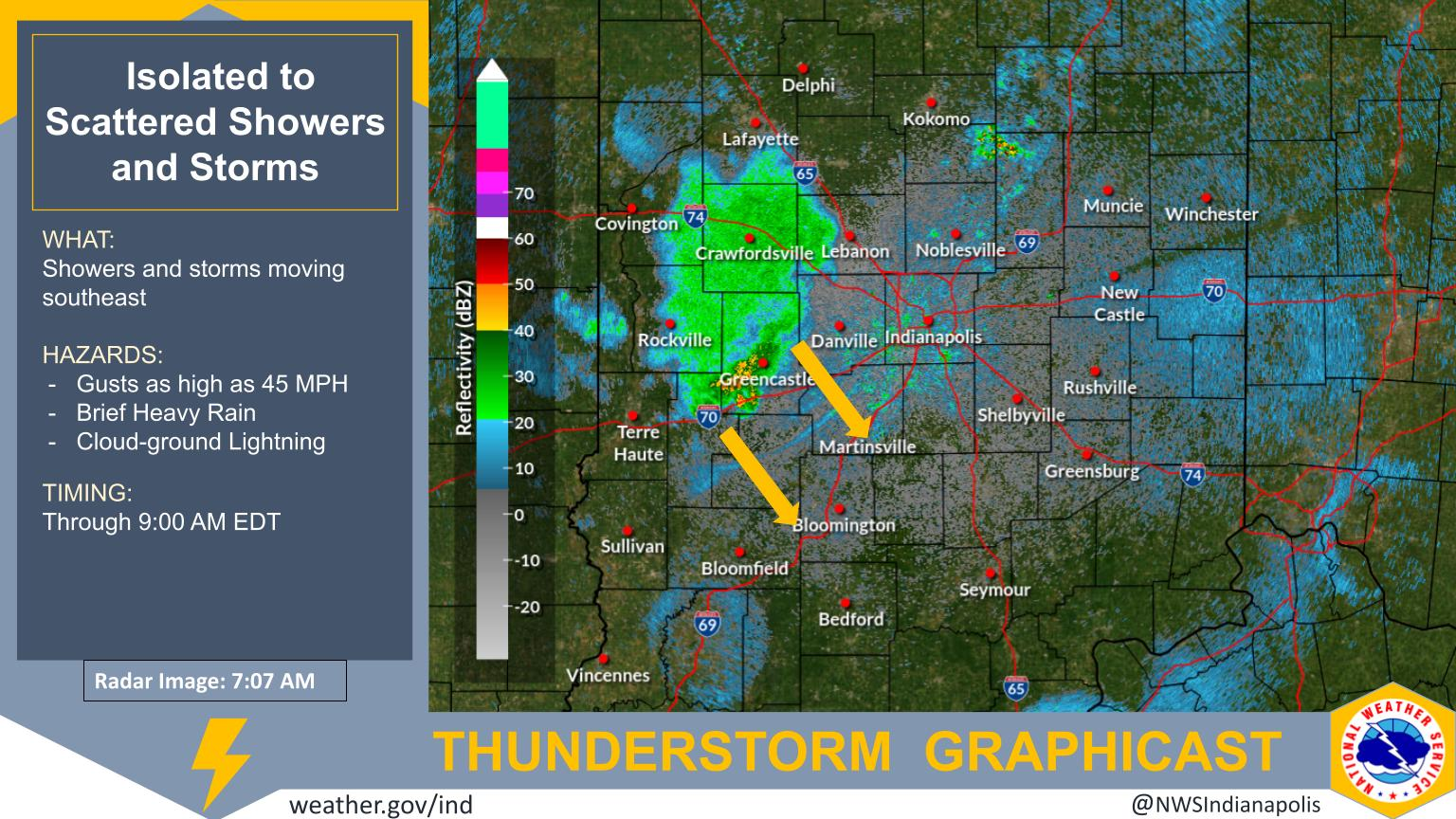
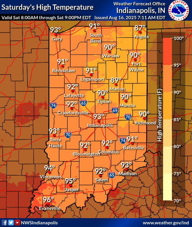
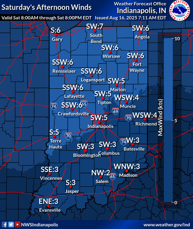
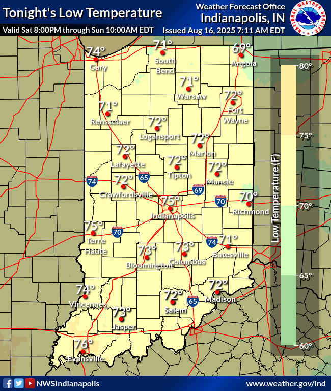
The potential for additional convective cells continues today,
albeit with lower confidence due to near-term disagreement of
convective allowing model guidance, and the overall conditional
nature of the set-up.  Of particular note will be 25-35KT of bulk
shear over western counties through 21Z...which should combine with
2500-3500 J/kg of MUCAPE after 18Z.  Although present clouds and
overall lackluster mid-level lapse rates will be mitigating factors.
Greatest threats will be marginally strong to severe winds and
torrential downpours...with small hail also possible in tallest
updrafts.

An upper high will continue to the west of central Indiana, and
upper energy will move around this high and bring forcing at times
to the area through tonight.

Even with cloud cover at times from convection to the west,
instability will build today and persist into tonight (though
diurnally lower tonight). The upper energy should interact with this
instability and produce scattered convection at times.

Mesoscale influences, such as surface boundaries from older
convection, could potentially have big impacts as well, increasing
the uncertainty on the specifics.

Given the uncertainties, will keep PoPs no higher than chance
category for now, with later updates refining/increasing as
necessary. Based on the expected position of the upper high, the
best chances for convection will be over the northern and eastern
portions of the forecast area.

There is enough weak shear for the potential of some isolated strong
to severe convection, mainly this afternoon and evening when
instability is maximized. Damaging winds would be the primary
threat, along with locally heavy rain.

High temperatures today will depend on how convection develops. For
now, will continue to undercut guidance a bit in the northeast where
odds of convection are highest. Even so, highs will be from around
90 northeast to lower and middle 90s southwest. Heat indices around
100 are possible in the warmest areas. Lows tonight will be in the
lower 70s.

Even though today could be the start of a string of days with heat
indices around 100 degrees, will hold off on issuing a Heat Advisory
(for prolonged near criteria heat) given the uncertainties in
convection and related effects.

&&

.LONG TERM (Sunday through Friday)...
Issued at 302 AM EDT Sat Aug 16 2025

Sunday through Monday...

An upper ridge centered near the region will allow unseasonably hot
and humid conditions to persist into early next week. Highs in the
low-mid 90s combined with high humidity will lead to peak heat
indices reaching around 100-105 degrees each afternoon. However, a
complicated convective forecast limits confidence in these expected
heat indices being reached.

The reason for limited confidence is guidance suggest upstream storm
complexes will propagate towards the area within northwest flow
aloft. It is typical for models to struggle with these subtle
impulses riding along the northern periphery of ridges. That is
evident in the widely varying solutions from both high resolution
and global models. Will stick to low POPs at times from blended
guidance given the high uncertainty, primarily over N/NE counties on
Sunday. Organized severe weather is unlikely due to weak deep-layer
shear. That being said, isolated strong to severe storms cannot be
ruled out given strong instability and steep low-level lapse rates.
The primary threats from storms would be localized heavy rain or
isolated damaging wind gusts.

POPs were not added for Monday as guidance depicts the upper ridge
axis shifting eastward into Indiana which could promote stronger
subsidence. Some convection cannot be ruled out on Monday, but will
keep the forecast dry at this time. Rain chances will likely need to
be refined in future updates once guidance becomes better aligned.
Any convection or convective cloud debris could limit daytime
heating or peak heat indices.

Tuesday onward...

Upper troughing setting up over the region Tuesday and Wednesday
along with a cold front moving through will support better chances
for precipitation. Uncertainty in exact details remains due to
diverging model solutions though. The greatest chance for
thunderstorms appears to be late Tuesday when the strongest forcing
and deeper moisture align. By Wednesday, guidance generally suggest
the front will have pushed through much of the area. Low POPs remain
in the forecast though as lingering low-level moisture and forcing
for ascent could promote isolated to scattered convection.

Peak heat indices around 100-105 are still possible Tuesday ahead of
the cold front before cooler air filters in mid-late week. Highs in
the low-mid 90s Tuesday should fall into the 80s mid-late week along
with lower humidity. Surface high pressure building in late
week will support mostly dry conditions.
INDY SEVEN DAY FORECAST
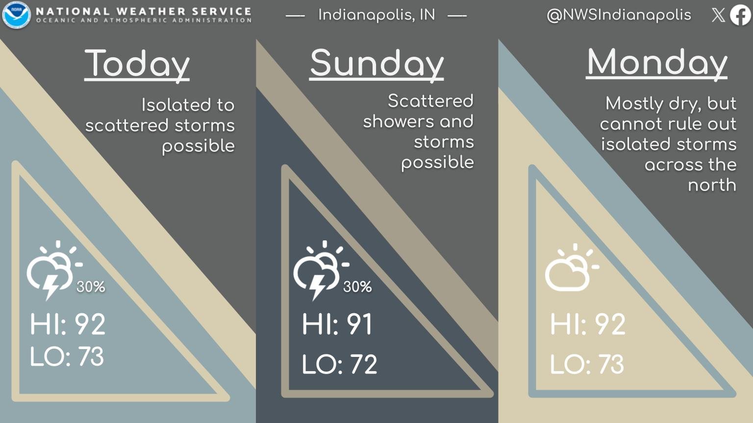
Saturday: Partly sunny. Hot and humid. Isolated late afternoon shower or storm possible. High 93.
Saturday Night: Partly cloudy. Spotty showers and storms possible. Low 74.
Sunday: Partly sunny. Isolated late afternoon shower or storm possible. High 94.
Sunday Night: Partly cloudy. Low 74.
Monday: Partly sunny, with spotty afternoon showers and storms. High 95.
Monday Night: Partly cloudy. Low 74.
Tuesday: Partly to mostly cloudy, with scattered showers and storms. High 92.
Tuesday Night: Scattered showers and storms. Low 71.
Wednesday: Partly to mostly cloudy, with scattered showers and storms mainly in the morning. High 84.
Wednesday Night: Partly cloudy. Not as humid! Low 66.
Thursday: Partly sunny. High 83.
Thursday Night: Mostly clear. Low 64.
Friday: Mostly sunny. High 86.

Never miss me! Subscribe for free. My Huge Radar has real-time weather tracking, current temperatures, and severe weather watches and warnings. Get detailed Indiana conditions by clicking here. Click here to see my central Indiana 7-Day Forecast. Follow these links to get my forecasts for Lafayette, Muncie, Hendricks County, and Hamilton County. Need a second opinion? Click here for central Indiana National Weather Service forecasts. (Some charts via WeatherBELL.)


