HEADLINES
– A mid-level low will pivot eastward and finally weaken today.
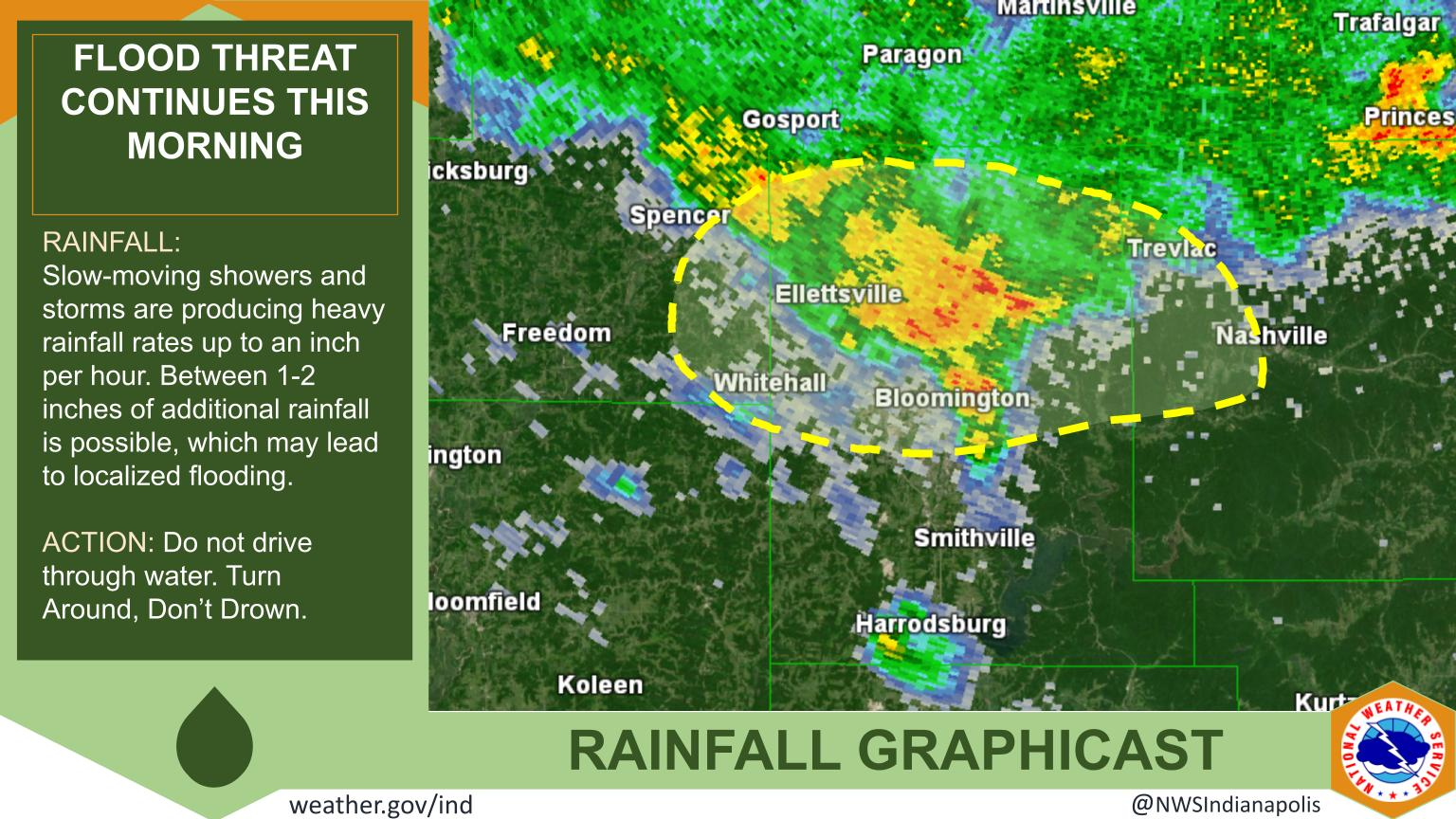
– It brought some flooding from around Bloomington to Terre Haute.
– Showers and some storms mainly east and southeast of Indy today.
– Hot and humid again by weekend. Next big storm chance is later Sunday.
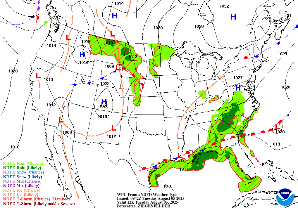
TODAY’S MAP
NWS TECHNICAL DISCUSSION
A brief lull in activity is possible before renewed destabilization
allows for showers and storms to regenerate during the afternoon
hours. The MCV/Mid-level low both appear weaker, so coverage is
probably not going to be as much as it was yesterday. Corfidi
upshear vectors are still slow, so storms may slow down and back-
build if they persist long enough to form a cold pool.

Precipitation chances are best across the central and southern parts
of our CWA. Continued low-level easterly flow across the northeastern
portions will allow more stable air to filter in, reducing the
precip chances somewhat.

As for temperatures, today will be a bit warmer than yesterday by a
few degrees. Increasing humidity is also expected, especially
further north where dry air was present much of the day yesterday.
Look for highs in the mid 80s.

After sunset, shower/storm activity will again diminish with some
patchy fog possible. Slightly warmer lows are expected due to
increasing humidity.

&&

.LONG TERM (Wednesday through Monday)...
Issued at 258 AM EDT Tue Aug 5 2025

No major changes were noted within long term ensemble guidance. Our
previous forecast philosophy remains and the previous discussion
will be retained.

-----------Previous Discussion-----------

Strong ridging aloft will remain anchored over the southern Rockies
and High Plains while a weakness in the flow lingers downstream
across the eastern Midwest and Ohio Valley through midweek. Isolated
to scattered afternoon and evening convection will persist on
Wednesday across the region but as the weakness diminishes and
ridging expands east late week...convective chances will decrease
into the weekend along with an increase in heat and humidity.

A more focused and widespread threat for convection will arrive by
the end of the weekend and into early next week in response to an
approaching cold front dropping out of the upper Midwest and
becoming nearly stationary over the region.

Tuesday Night and Wednesday

A weak but persistent level of troughiness aloft on the lee side of
the ridge will remain across the Ohio Valley through Wednesday
gradually shifting eastward. This will maintain isolated to
scattered convection across especially the southeast half of the
forecast area into Wednesday with a continued risk for slow moving
localized downpours that generally remain subsevere during peak
heating. However any stronger cell with a collapsing downdraft will
carry a localized gusty wind threat.

Highs will climb into the mid 80s Wednesday with humidity levels
slowly ticking up as well as progressively deeper moisture advects
into the region.

Wednesday Night through Monday

Heights aloft will respond to an expansion of the ridging to our
west late this week into the weekend resulting in a resumption of
the late July hot and humid regime albeit with temperatures and
humidity levels not quite as high as experienced last week. Highs
will rise into the upper 80s and lower 90s Friday through Sunday
with dewpoints near or above 70 degrees which could bring peak heat
indices into the upper 90s over the weekend.

The presence of deep low level moisture and ample instability will
keep the risk for isolated afternoon and evening convection in play
but overall daily coverage will decrease with the development of a
mid level cap and the loss of forcing aloft. By late weekend into
early next week...a cold front will shift south towards the region.
While this would provide increased forcing aloft for more widespread
and robust convection... there remain hints in the long range
guidance at the front becoming nearly stationary to our north across
the lower Great Lakes through much of next week as it runs into the
ridging further south. This would keep a warm...humid and unsettled
pattern across the Ohio Valley with any substantial cooldown coming
from a frontal passage being delayed until late next week at the
earliest.
INDY SEVEN DAY FORECAST
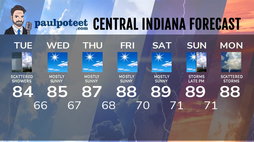
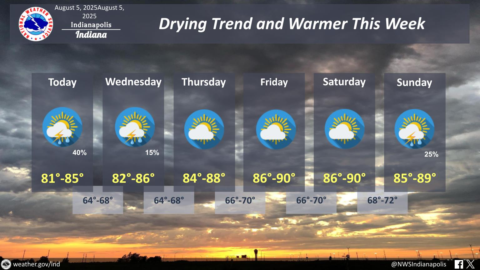
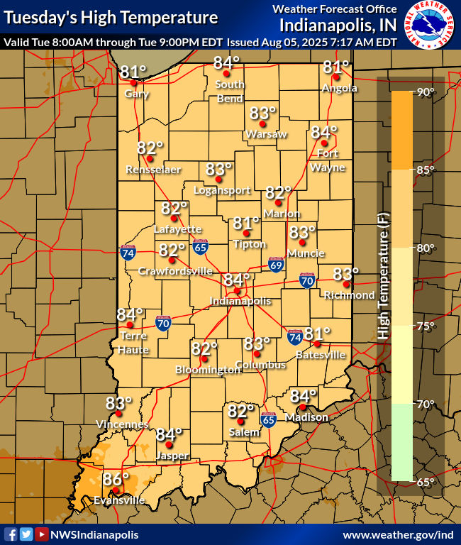
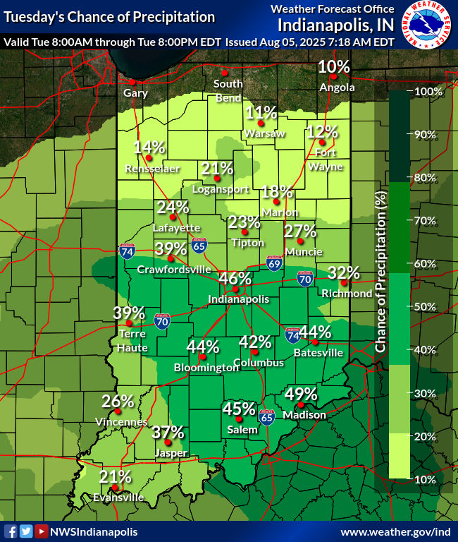
Today: Becoming partly sunny and warmer. Humidity increases. Spotty showers possible in the morning. Spotty showers and storms possible in the afternoon. High 84.
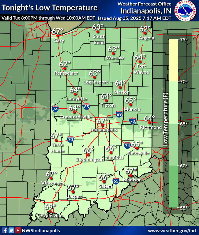
Tonight: Partly cloudy. Spotty showers or storms possible. Low 66.
Wednesday: Mostly sunny. High 85.
Wednesday Night: Mostly clear. Low 67.
Thursday: Mostly sunny. High 87.
Thursday Night: Mostly clear. Low 68.
Friday: Mostly sunny. High 88.
Friday Night: Mostly clear. Low 70.
Saturday: Mostly sunny, hot and humid. High 89.
Saturday Night: Mostly clear. Low 71.
Sunday: Partly cloudy. Scattered showers and storms by late afternoon. High 89.
Sunday Night: Scattered showers and storms. Low 71.
Monday: Partly to mostly cloudy, with scattered showers and storms. High 88.
Never miss me! Subscribe for free. My Huge Radar has real-time weather tracking, current temperatures, and severe weather watches and warnings. Get detailed Indiana conditions by clicking here. Click here to see my central Indiana 7-Day Forecast. Follow these links to get my forecasts for Lafayette, Muncie, Hendricks County, and Hamilton County. Need a second opinion? Click here for central Indiana National Weather Service forecasts. (Some charts via WeatherBELL.)


