HEADLINES
– Last 9pm sunset of the year today in Indy!
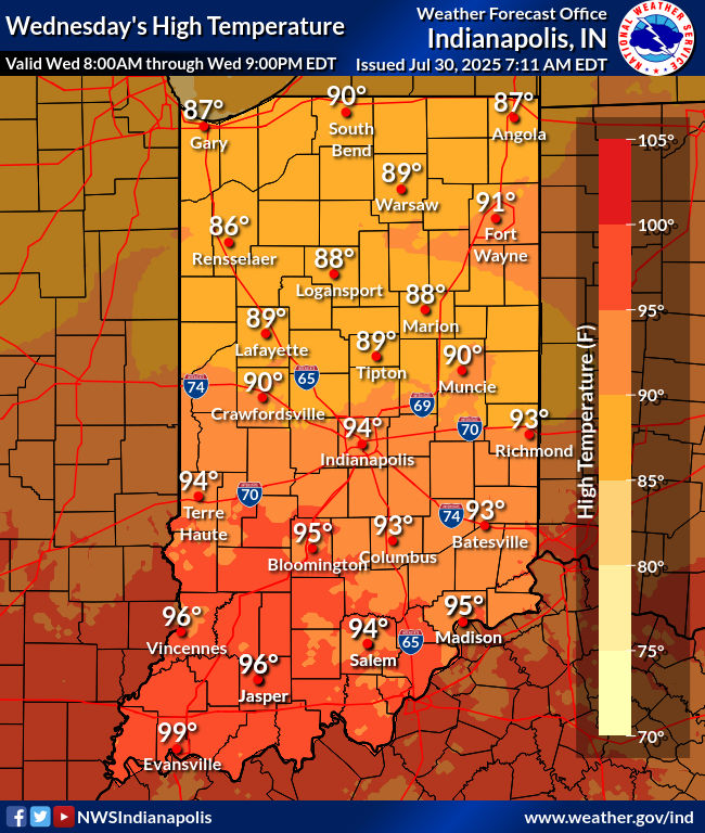
– Yesterday was the hottest of the year in Indy, with a high of 95. That’s the 20th 90+ day this season.
– Lafayette has had 14 such days, and Muncie has had 13. Both have had highest temps of 93.
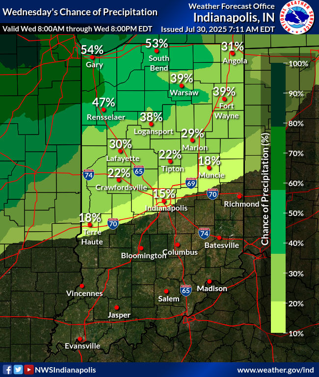
– Showers and storms by this evening into mainly tomorrow morning with a cold front.
– Much lower heat and humidity follows through the weekend.
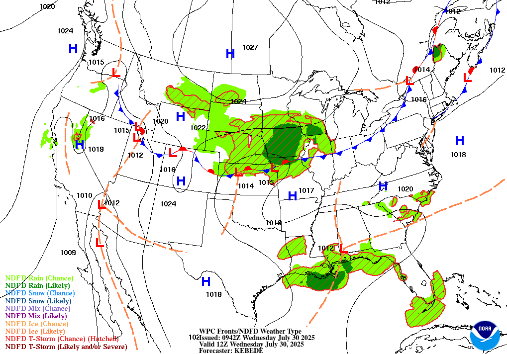
TODAY’S MAP
NWS TECHNICAL DISCUSSION
Forecast confidence today is fairly low with much of the uncertainty
depending on the track and longevity of the ongoing convection
across Iowa. Models have been strongly suggesting that this complex
will weaken and eventually dissipate towards daybreak but with
modest instability out ahead of the storms, this complex is more
likely than not going to outlast the model solutions. The theta-e
axis would keep the majority of the convection north of the forecast
area through the day but outflow boundaries moving south may be
initiation points towards the afternoon and evening. Better chances
for convection across central Indiana look to be later into the
overnight as the subtle front/outflow boundary begins to shift
southward as a stronger upper level wave moves in aloft.

No changes planned to the ongoing Heat Advisory. Temperatures will
have no issue rising into the low to potentially mid 90s again
today. Dew points will be a bit lower today compared to yesterday
which would put heat index values on the lower end of criteria but
with this going on Day 8 of much warmer than normal temperatures,
the cumulative impacts of the heat continue to increase. Cloud cover
across the northern counties due to overnight convection should
limit the higher-end values.

Tonight.

As the front dips southward, rain chances will increase through the
late evening into overnight hours with the potential for flooding as
thunderstorms will be moving eastward along the front which will
bring multiple hours of moderate to locally heavy rain. Confidence
in this heavier rain will be along and north of I-70 with the
expected storm coverage lower further south. Additional showers and
storms are likely to continue into Thursday before the front fully
pushes south of the forecast area and the long-advertised relief
from the heat arrives.

&&

.LONG TERM (Thursday through Tuesday)...
Issued at 245 AM EDT Wed Jul 30 2025

Thursday...

As Thursday begins, an upper wave will be over Indiana, along with
surface low pressure expected near the Ohio River. The weak
boundary, which will be a focus for convection, will have pushed
farther south, closer to the Ohio river. Lingering moisture and
showers may still be across the area as the day begins. Forecast
soundings show a nearly saturated column through mid-day, with mid
level subsidence not arriving until the afternoon. HRRR continues to
suggest lingering showers across the area in the morning. Thus high
pops are expected to be in place on Thursday along with cloudy
skies. Northeasterly surface winds and cold air advection will be in
place on Thursday, leading to much cooler highs in the upper 70s to
near 80.

Friday through Sunday...

A great summer weekend is ahead. Strong ridging in place aloft over
the Rockies will result in subsidence across the Great Lakes and
Ohio Valley. This will result in the development of a strong surface
high pressure system that will be slowly moving through the Great
Lakes to the northeast through the weekend. This high pressure
system will provide a flow of cooler and less humid, continental air
on northeasterly winds. Forecast soundings show a very dry column
indicative of mostly clear skies. Thus expect a super pleasant
weekend with highs in the lower 80s and lows in the upper 50s to
around 60s.

Monday and Tuesday...

Daily chances for showers and thunderstorms will return to the
forecast on Monday and Tuesday. The first factor contributing to
this will be the departing area of high pressure. As the large
surface high departs by Monday, winds will become southerly,
allowing the return of more humid southerly flow from the gulf. The
second factor is aloft. Models suggest a broad upper trough pushing
toward Indiana on Monday and arriving on Tuesday. These factors will
at least necessitate the need for at least chance pops.
INDY SEVEN DAY FORECAST
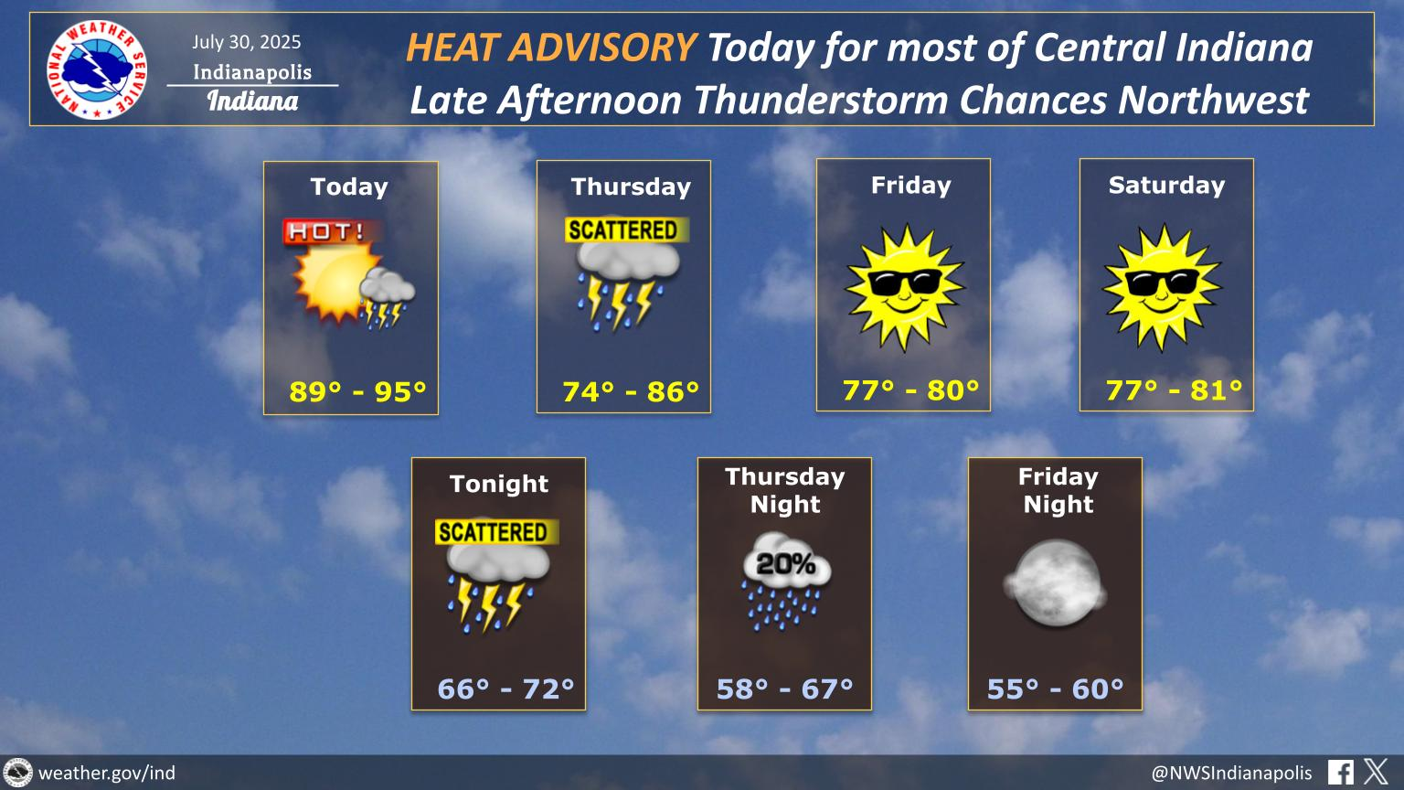
Today: Partly sunny, hot and humid. High 93.
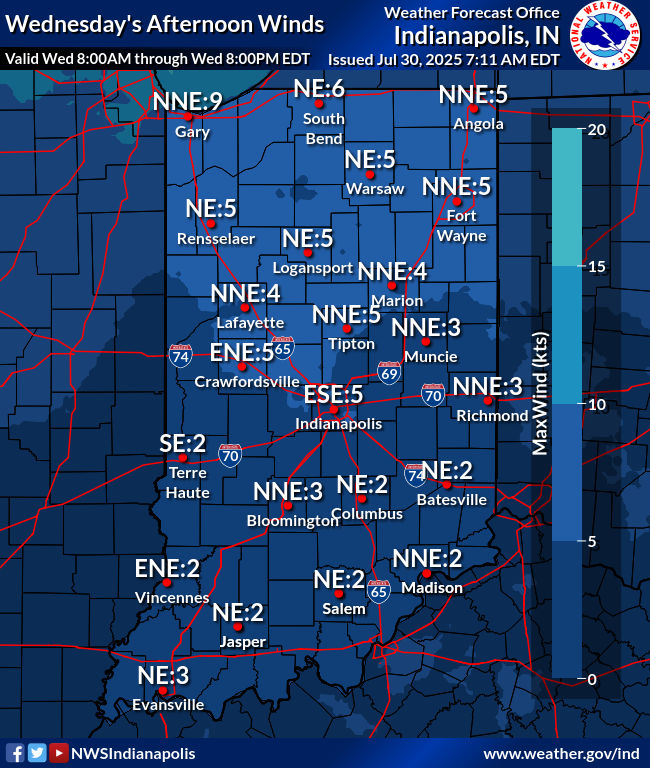
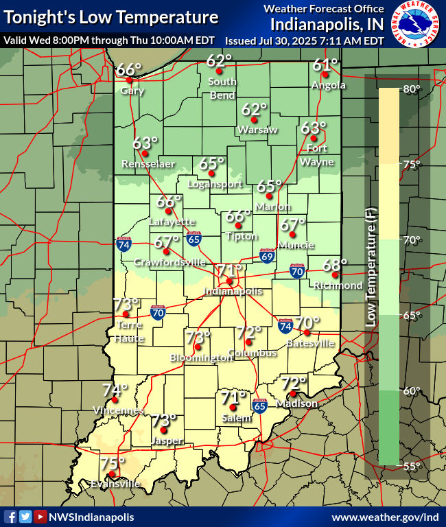
Tonight: Scattered showers and storms. Some could produce damaging wind gusts. Low 70.
Thursday: Scattered showers, and maybe some thunder…mainly in the morning. Not as hot! High 79.
Thursday Night: Partly cloudy and much less humid. Low 62.
Friday: Mostly sunny. High 78.
Friday Night: Mostly clear. Low 58.
Saturday: Mostly sunny. High 79.
Saturday Night: Partly cloudy. Low 58.
Sunday: Partly sunny. High 82.
Sunday Night: Partly cloudy. Low 64.
Monday: Partly sunny. High 83.
Monday Night: Partly cloudy. Scattered showers and storms after sunset. Low 66.
Tuesday: Partly sunny, with scattered showers and storms. High 82.


Never miss me! Subscribe for free. My Huge Radar has real-time weather tracking, current temperatures, and severe weather watches and warnings. Get detailed Indiana conditions by clicking here. Click here to see my central Indiana 7-Day Forecast. Follow these links to get my forecasts for Lafayette, Muncie, Hendricks County, and Hamilton County. Need a second opinion? Click here for central Indiana National Weather Service forecasts. (Some charts via WeatherBELL.)


