HEADLINES
– Thunderstorms this afternoon, mainly south of I-70.
– Isolated damaging winds gust and localized flooding is possible.
– Fairly quiet after sunset through Friday. Rain/storms return Friday night.
– Showers and storms likely this weekend. Heavy rainfall and damaging wind gusts possible Saturday.
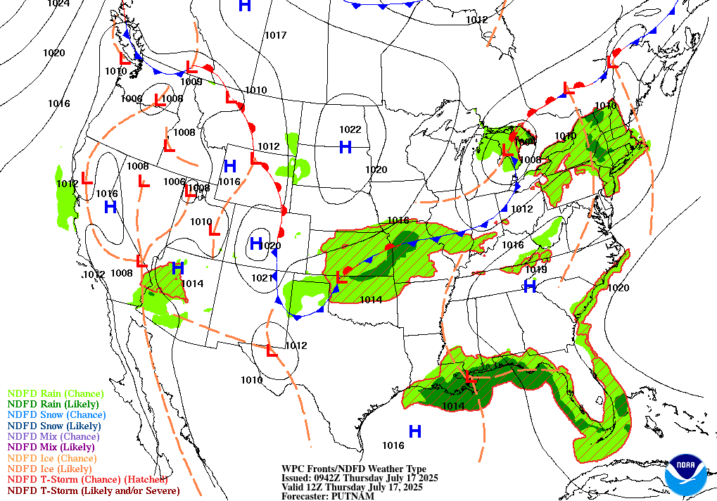
TODAY’S MAP
NWS TECHNICAL DISCUSSION
Today's showers/storms: highest coverage afternoon and evening across
the southern counties with wet microbursts being the primary threat
along with an additional threat for flooding as the convection will
be moving slowly.

&&

.SHORT TERM (Today and tonight)...
Issued at 230 AM EDT Thu Jul 17 2025

General zonal upper flow will remain just to the north of central
Indiana, but a subtle shortwave has allowed for pressure depletion
and to passage of a weak frontal boundary. As this boundary passes
through today, scattered to numerous thunderstorms are expected to
initiate and move to the E/SE around 20-25kts. Greatest coverage
will likely remain over far southern central Indiana, but isolated
thunderstorms will be possible over the entirety of the region this
afternoon.

Forecast soundings ahead of storm initiation are rather buoyant, with
moisture elevated through the entire column. This will likely lead
to a broken line of efficient rain producers and scattered wet
microburst signatures. These microburst should remain mostly
subsevere given lack of low level shear and DCAPE values of 700-800
J/kg, but a few of these could reach severe wind gust criteria
across southern Indiana this afternoon. Some localized flooding will
be possible as well given high rain rates and the potential for
training given a small angle between frontal orientation and storm
motion. Expect a general 0.25-0.5" of QPF with isolated amounts up
to 3". A secondary push of moisture is expected to move into the
Ohio Valley tonight into Friday morning. Coverage of showers and
storms are expected to remain below 40%.

&&

.LONG TERM (Friday through Wednesday)...
Issued at 230 AM EDT Thu Jul 17 2025

Friday Through Sunday...

A series of upper waves, a meandering surface front, and plentiful
moisture will keep chances for rain around through the weekend.

Initially the front will be across southern Indiana, and this should
keep the highest chances for rain across southern areas on Friday.
Afterward, the front will meander north and south across the area,
influenced by the upper waves and the convection generated by those
waves. This will move the location of highest PoPs around on a daily
basis.

Uncertainty in the timing of the upper waves as well as mesoscale
influences from convection makes confidence low to very low in
regards to timing and location of the highest PoPs.

Moisture will be plentiful, and convection may move over the same
locations multiple times. This alone will create a threat for heavy
rain and localized flooding. However, there is a potential that some
of the tropical moisture from the system currently in the Gulf could
be brought into the system, increasing the threat for heavy rain and
flooding. Will have to keep an eye on how this develops. At this
point, WPC`s Slight Risk for Excessive Rainfall for this weekend
looks good.

Temperatures will ultimately depend on the timing of convection and
the resultant cloud cover, but highs in the middle 80s to around 90
look reasonable. Dewpoints in the mid 70s will make it feel like the
90s.

Monday and beyond...

An upper high will build into the area by mid-week next week. As it
does, chances for showers and storms will diminish. Temperatures
will warm, with highs in the lower and middle 90s common by Tuesday.

Plentiful low level moisture will remain, aided in part by
evapotranspiration. Dewpoints will get into the middle and upper
70s. The combination of the temperatures and dewpoints will  produce
heat indices above 105 degrees. Heat headlines may be needed by mid-
week next week.

Heat Risk maps are showing some Major category in the area by
Tuesday with widespread Major category on Wednesday.
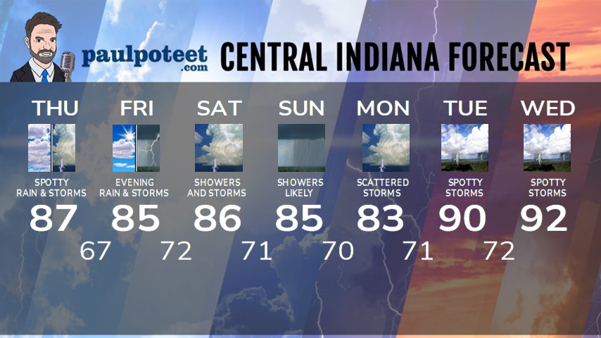
INDY SEVEN DAY FORECAST
Today: Partly to mostly cloudy. Scattered showers and storms, especially from I-70 southward. High 87.
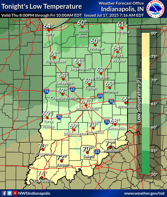
Tonight: Mostly cloudy. Isolated shower or storm until around sunset. Low 67.
Friday: Partly to mostly cloudy. Isolated shower possible. High 85.
Friday Night: Humidity increases again. Scattered showers and storms return. Low 72.
Saturday: Partly to mostly cloudy, with showers and storms likely. Heavy rain and damaging wind gusts possible in the afternoon. High 86.
Saturday Night: Showers and storms. Heavy rain and damaging wind gusts possible. Low 71.
Sunday: Showers likely. Some thunder possible. High 85.
Sunday Night: Scattered showers and storms. Low 70.
Monday: Partly to mostly cloudy. Scattered showers and storms. High 83.
Monday Night: Partly to mostly cloudy. Scattered showers and storms. Low 71.
Tuesday: Partly sunny. Spotty showers and storms. High 90.
Tuesday Night: Partly cloudy. Spotty showers and storms. Low 72.
Wednesday: Partly sunny. Spotty showers and storms. High 92.


Never miss me! Subscribe for free. My Huge Radar has real-time weather tracking, current temperatures, and severe weather watches and warnings. Get detailed Indiana conditions by clicking here. Click here to see my central Indiana 7-Day Forecast. Follow these links to get my forecasts for Lafayette, Muncie, Hendricks County, and Hamilton County. Need a second opinion? Click here for central Indiana National Weather Service forecasts. (Some charts via WeatherBELL.)


