HEADLINES
– Isolated showers and storms today, mainly in East Central Indiana.
– Scattered showers and storms tonight. A few storms could produce damaging wind gusts.
– Scattered storms Thursday afternoon and evening. Again, a few could be severe.
– Lower temps and humidity Friday. Rain could be heavy at times Saturday.
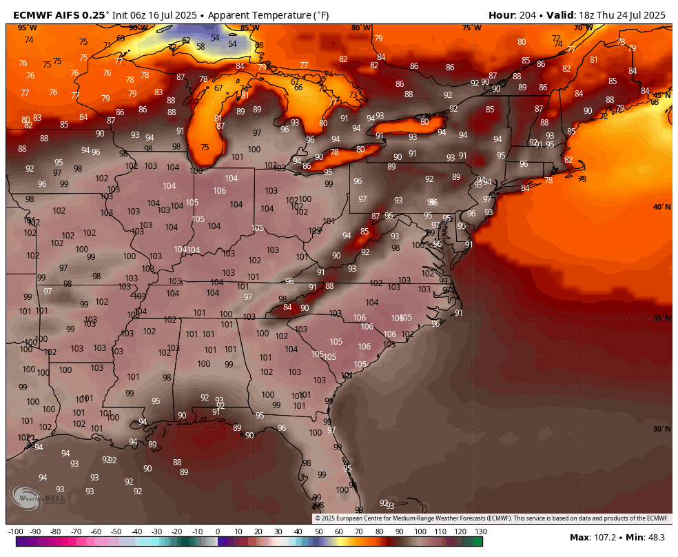
! 100+ heat index numbers next Wednesday through Friday !
TODAY’S MAP
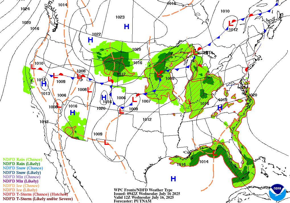
NWS TECHNICAL DISCUSSION
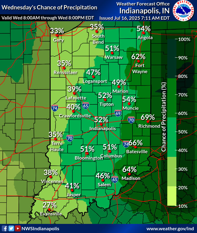
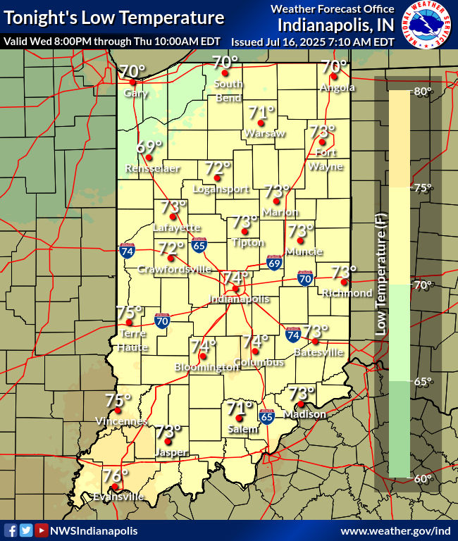
A series of upper impulses will move across central Indiana into the
afternoon. There won`t be much of a surface feature over central
Indiana, with perhaps a weak surface trough moving through this
morning.

Plentiful moisture will be in place with precipitable water values
continuing around 2 inches. Thus feel that the combination of the
aforementioned forcing and moisture will produce scattered to
numerous showers and thunderstorms across the area into the
afternoon.

Coverage of convection looks to be highest across the eastern
forecast area, which will have a chance to build up more instability
by early afternoon. Shear will be weak, so feel odds of a severe
storm are low during much of the today period. Heavy rain will be
the primary threat, along with some gusty subsevere winds.

Chances for rain will diminish west to east during the afternoon as
forcing from the upper energy exits.

Temperatures should still be able to reach the middle 80s to around
90 as coverage of convection diminishes this afternoon. The western
forecast area will see the warmest temperatures given more sunshine
is expected there.

Late Today into Tonight...

Thunderstorms will develop ahead of an approaching cold front west
of the area later today. Some of these may move into central Indiana
this evening. Increasing wind speeds aloft ahead of the system will
increase the shear across central Indiana. The instability and shear
will be enough for the potential of an isolated severe storm, mainly
across the western forecast area.

These initial storms should outrun the better forcing and then
weaken as the evening progresses. However, as the cold front
approaches overnight, additional convection may pop up.

Will have slight chance to chance category PoPs during the night.
Highest PoPs will be in the northwest closer to the better forcing.

Lows tonight will be in the lower 70s.

&&

.LONG TERM (Thursday through Tuesday)...
Issued at 234 AM EDT Wed Jul 16 2025

There is still a strong consensus on a typical, but moist mid
summer pattern for central Indiana late this week through the
weekend. This will likely entail daily chances for diurnally
induces scattered precipitation along with highs in the mid to upper
80s and dew points in the low 70s. Synoptically, this is being
created by strong ridging over the SE CONUS along with modest quasi-
zonal flow over the Northern Plains and Upper Great Lakes regions.

With that said, there is still going to be some slight fluctuations
day to day due to a few low level features passing through Thursday
and Friday. Per the 00Z ensemble suite, there is increasing
confidence in a low level boundary slowly pushing eastward, of which
could create a greater coverage of convection Thursday evening and
night across southern portions of the State. There is some potential
for isolated severe wind gusts, but confidence is not high. This
also may allow for slightly cooler temperatures (mid 80s) and less
storm coverage on Friday.

Uncertainty increases some for the weekend, mainly due to cascading
upstream mesoscale impacts that are not typically resolved well in
the global models. One feature we are closely monitoring for the
weekend, is the potential for weakening tropical remnants to push
northward into the Ohio Valley. Latest trends are pushing the bulk
of the forcing and moisture further south towards the Tennessee
Valley, but there are still a contingent of ensemble solutions
keeping the northern track. The track of these remnants will greatly
impact moisture levels for central Indiana, and therefor confidence
is predicated on how this evolves. Regardless, as stated previously,
a consistent summer-like airmass should remain.
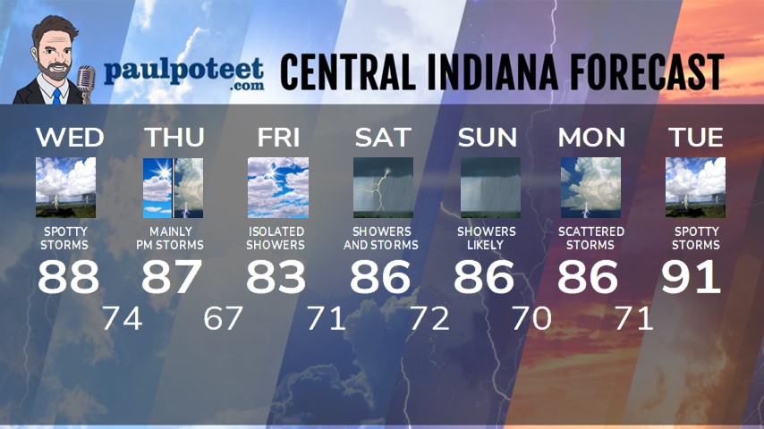
INDY SEVEN DAY FORECAST
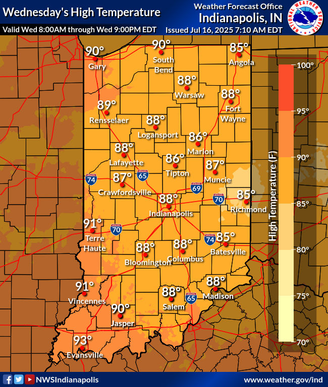
Today: Mostly to partly cloudy. Spotty showers and storms, mainly in the morning. High 88.
Tonight: Spotty evening showers and storms. Some storms could produce damaging wind gusts. Partly cloudy overnight. Low 74.
Thursday: Partly cloudy, with mainly afternoon showers and storms. Some could be strong to severe. High 87.
Thursday Night: Showers and storms end early. Mostly cloudy and a little less humid. Low 67.
Friday: Partly to mostly cloudy, with an isolated shower possible. Not as humid. High 83.
Friday Night: Mostly cloudy. Low 71.
Saturday: Mostly cloudy, with showers and storms likely. Humidity increases. High 86.
Saturday Night: Scattered showers and storms. Low 72.
Sunday: Showers likely. Some thunder possible. High 86.
Sunday Night: Scattered showers and storms. Low 70.
Monday: Scattered showers and storms. High 86.
Monday Night: Partly cloudy. Spotty showers and storms. Low 71.
Tuesday: Partly sunny. Spotty showers and storms. High 91.

Never miss me! Subscribe for free. My Huge Radar has real-time weather tracking, current temperatures, and severe weather watches and warnings. Get detailed Indiana conditions by clicking here. Click here to see my central Indiana 7-Day Forecast. Follow these links to get my forecasts for Lafayette, Muncie, Hendricks County, and Hamilton County. Need a second opinion? Click here for central Indiana National Weather Service forecasts. (Some charts via WeatherBELL.)


