HEADLINES
– Today looks to be the hottest day this week. Humidity TFN!
– Scattered showers & storms this afternoon and evening.
– Scattered showers and maybe some thunder Wednesday.
– More organized storms Thursday. Could be strong to severe.
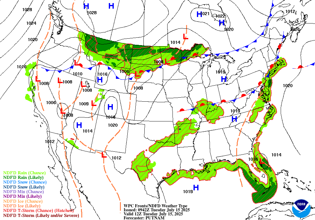
TODAY’S MAP
NWS TECHNICAL DISCUSSION
Moisture will continue to move north ahead of an approaching upper
wave. Some convection may accompany this moisture, but with lack of
significant forcing will keep coverage low. Will have some low PoPs,
mainly confined to the far south and southwest portions of central
Indiana.

Patchy fog will be possible given the moisture content of the low
level atmosphere.

Today...

Any patchy fog will mix out early. Moisture will continue to
increase from the south today, and the upper wave will move into the
area. Skies will be partly cloudy, but enough sunshine will get
through to boost temperatures into the middle 80s most areas today.

Those high temperatures will allow instability to build. The
instability, along with plentiful moisture, will be available for
the forcing from the upper wave to work with. This will generate
scattered to numerous convection this afternoon.

Will have some lower PoPs mainly south this morning for any initial
convection with the increasing moisture, but then go high chance
category to likely category PoPs this afternoon as the convection
develops.

Shear will be weak, so severe storms are not expected. However, deep
moisture with precipitable water values over 2 inches will lead to
the possibility of heavy rain and localized flooding. The deepest
moisture will be across southern half of the area, so that is where
the highest threat for heavy rain will be. HREF local probability
matched mean show the possibility of localized rainfall amounts over
3 inches.

Tonight...

Convection will diminish this evening with loss of heating and the
exit of the initial upper wave. However, another upper wave will
move in overnight. 850mb winds increase some as well. These will be
enough for more convection to develop.

Will have PoPs increase overnight, at least into the higher end of
the chance category. Locally heavy rain will again be the primary
threat from any convection.

Low temperatures will be from around 70 into the lower 70s.

&&

.LONG TERM (Wednesday through Monday)...
Issued at 224 AM EDT Tue Jul 15 2025

A very typical summer pattern is expected for the Ohio Valley later
this week though the weekend. This is thanks to a strong high
pressure system over the SE CONUS and a subsequent zonal jet flow in
the 200-400mb layer just to the north. The result will be a long
stretch of seasonal temperatures with moderately high dew points (70-
75F) daily.

With central Indiana on the north side of the high pressure
system and surface moisture elevated, daily diurnal thunderstorm
chances are expected. There will likely be a few weak low level
features that may aid in some scattered non-diurnal
showers/storms, but that should be more the exception than the
rule.

The main exception will be Late Wednesday through Thursday as a weak
shortwave develops in the upper level flow, aiding in slightly
greater low level pressure depletion and the potential for a more
organized convective system across the northern Mississippi Valley
to potentially the Ohio Valley.
INDY SEVEN DAY FORECAST
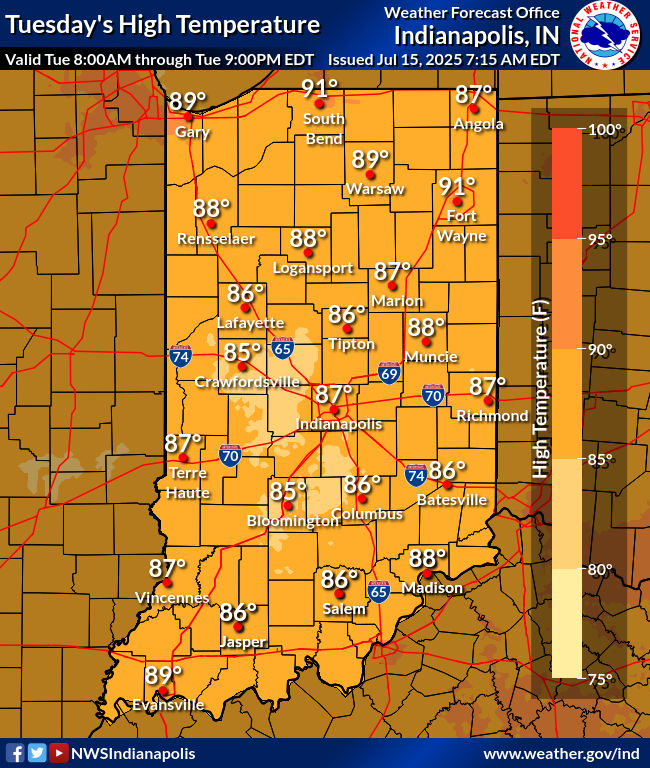
Today: Partly sunny. Scattered afternoon showers and storms. High 86.
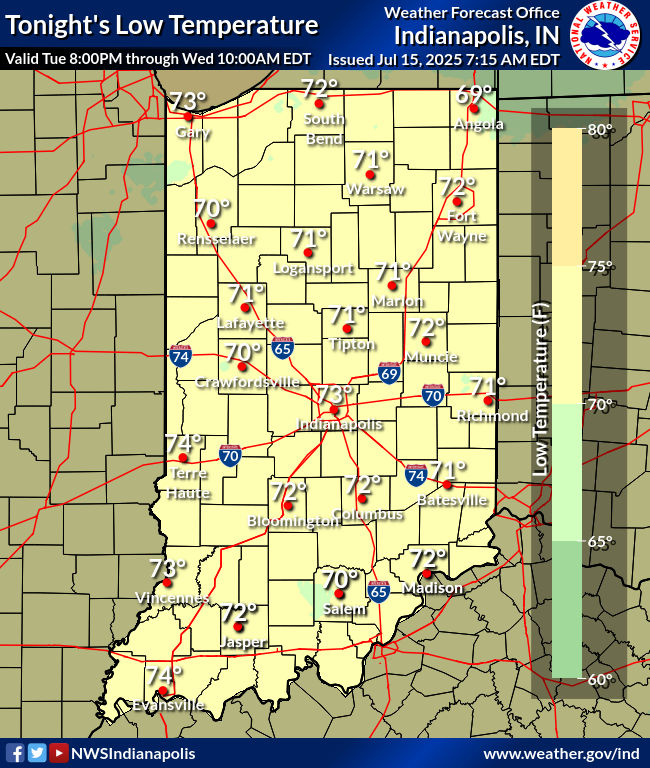
Tonight: Scattered showers and storms. Low 72.
Wednesday: Partly to mostly cloudy, with scattered showers. Thunder also possible. High 87.
Wednesday Night: Partly cloudy. Low 73.
Thursday: Mostly cloudy, with mainly afternoon showers and storms. Some could be strong to severe. High 86.
Thursday Night: Showers and storms. Some could be strong to severe. Low 67.
Friday: Partly to mostly cloudy, with a few spotty showers possible. High 83.
Friday Night: Mostly cloudy. Low 68.
Saturday: Mostly cloudy, with showers and storms likely. High 85.
Saturday Night: Scattered showers and storms. Low 71.
Sunday: Scattered showers and storms. High 85.
Sunday Night: Scattered showers and storms. Low 70.
Monday: Scattered showers and storms. High 85.


Never miss me! Subscribe for free. My Huge Radar has real-time weather tracking, current temperatures, and severe weather watches and warnings. Get detailed Indiana conditions by clicking here. Click here to see my central Indiana 7-Day Forecast. Follow these links to get my forecasts for Lafayette, Muncie, Hendricks County, and Hamilton County. Need a second opinion? Click here for central Indiana National Weather Service forecasts. (Some charts via WeatherBELL.)


