HEADLINES
– Warm front has lifted over the state overnight. Bit more humid today, with the return of scattered showers and storms.
– Bit less humid and partly cloudy Thursday. Radar pretty quiet again Friday.
– Showers and storms this weekend. Could be heavier rain and some strong storms Saturday.
TODAY’S MAP

NWS TECHNICAL DISCUSSION
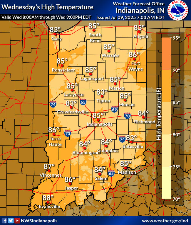
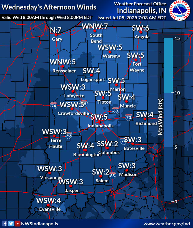
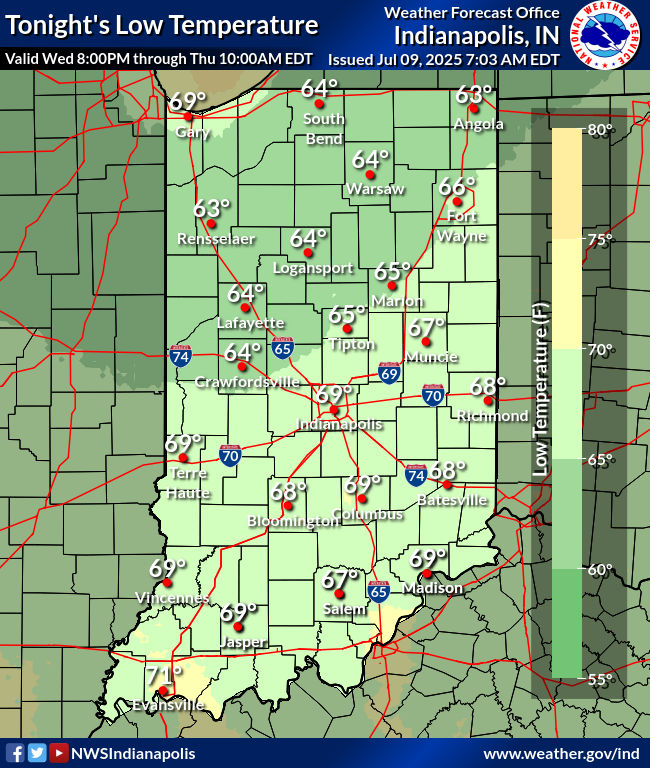
Remnant pockets of showers continue to drift across the northern
Wabash Valley southwest into eastern Illinois in tandem with an
upper level wave and a weak surface front. The airmass remained dry
below 10kft over much of the region with mid level clouds
increasing. 06Z temperatures ranged from the upper 60s to the mid
70s.

The aforementioned upper wave and surface boundary will track across
the region today and provide at least the opportunity for scattered
convective development with a moist and unstable airmass across
central Indiana. As this shifts off to the east this evening... weak
high pressure will expand into the area with slightly drier air.

Cannot rule out scattered showers continuing to develop across the
northwest half of the forecast area through much of the morning but
the current ACARS sounding at KIND highlights the problems in the
lower levels of the atmosphere that will likely limit broader
convective development over the next several hours. Mainly...the air
remains dry up into the 600-500mb layer with negligent instability.
Much of the better forcing aloft is displaced to the north across
lower Michigan as well. Will maintain low pops through late morning
but most locations will remain dry due to the extenuating factors
above.

Low level moisture will improve this afternoon along and ahead of
the front as it moves into the forecast area and this will aid in
MLCAPES peaking at near 2000 j/kg. But the forcing aloft will remain
weak with little to near shear as well. This will likely keep
convection in a scattered and disorganized state focused especially
across the southeast half of the forecast area ahead of the
boundary. Once again as has been the case for the last several
days...primary threats from convection this afternoon will be brief
and localized heavy rainfall and cloud to ground lightning.

Convection will linger into the evening across eastern counties
before departing to the east as weak high pressure expands south
from the western Great Lakes. Despite dry air advecting in
overnight...potential for patchy fog will exist in the predawn hours
Thursday as winds lighten to near calm levels and skies clear.

Temps...low level thermals support mid 80s across the forecast area
today. With the arrival of a slightly drier airmass tonight...lows
will fall into the mid and upper 60s.

&&

.LONG TERM (Thursday through Tuesday)...
Issued at 245 AM EDT Wed Jul 9 2025

Overall typical midsummer weather is expected through the long term
as generally very warm and humid conditions with scattered diurnally-
driven convection...surround a couple rather brief less humid and
mainly rain-free periods.  Synoptically, North America will be more
trough dominant, although only along the Canadian border and
north...while any attempts of the southern subtropical ridge to
regain momentum is suppressed to the southwestern CONUS through at
least this weekend. In between these features, weak zonal flow will
carry embedded small weaknesses into the Midwest through Saturday...
before light southwest flow tries to quietly build the ridge towards
Indiana, bringing a marginally-hot set-up around next Monday and
onward.

This will all translate to more early mornings usually starting in
the upper 60s/lower 70s, with higher humidity capping diurnal
spreads up to around 85-90F.  Maximum afternoon heat indices usually
in the upper 80s to mid-90s...may approach 100F on Saturday, and
again at the end of the long term.  Widely scattered afternoon/
evening showers and thunderstorms will be the rule most days...while
occasional modest wind shear may promote a few stronger storms. Best
opportunity for greater coverage of rain/storms will be around the
Saturday period when a more amplified northern wave should drag a
weak cold front across the region. Milder and less humid conditions
will hopefully accompany subtle drops in heights/H850 temperatures/
precipitable water both at the start of the long term and then
through the latter half of the weekend, when several northern zones
may observe a tandem of overnights dropping into the mid-60s.
Indianapolis` normal max/min will maintain the year`s peak values
through July 22...85/67.
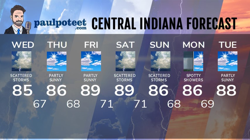
INDY SEVEN DAY FORECAST
Today: Partly to mostly cloudy. Scattered showers and storms. High 85.
Tonight: Partly cloudy. Spotty shower or storm possible in the evening. Low 67.
Thursday: Partly sunny. High 86.
Thursday Night: Partly cloudy. Low 68.
Friday: Partly sunny. High 89.
Friday Night: Partly cloudy. Low 71.
Saturday: Partly to mostly cloudy. Scattered showers and storms, especially in the afternoon. High 89.
Saturday Night: Scattered showers and storms. Low 71.
Sunday: Partly to mostly cloudy. Scattered showers and storms. High 86.
Sunday Night: Scattered showers and storms. Low 68.
Monday: Partly to mostly cloudy. Spotty showers possible. High 86.
Monday Night: Partly cloudy. Low 69.
Tuesday: Partly sunny. High 88.


Never miss me! Subscribe for free. My Huge Radar has real-time weather tracking, current temperatures, and severe weather watches and warnings. Get detailed Indiana conditions by clicking here. Click here to see my central Indiana 7-Day Forecast. Follow these links to get my forecasts for Lafayette, Muncie, Hendricks County, and Hamilton County. Need a second opinion? Click here for central Indiana National Weather Service forecasts. (Some charts via WeatherBELL.)


