HEADLINES
– Nice and less humid today, with some storms tomorrow.
– Nice Thursday, with some storms Friday!
– Good chances Saturday, dry on Sunday.
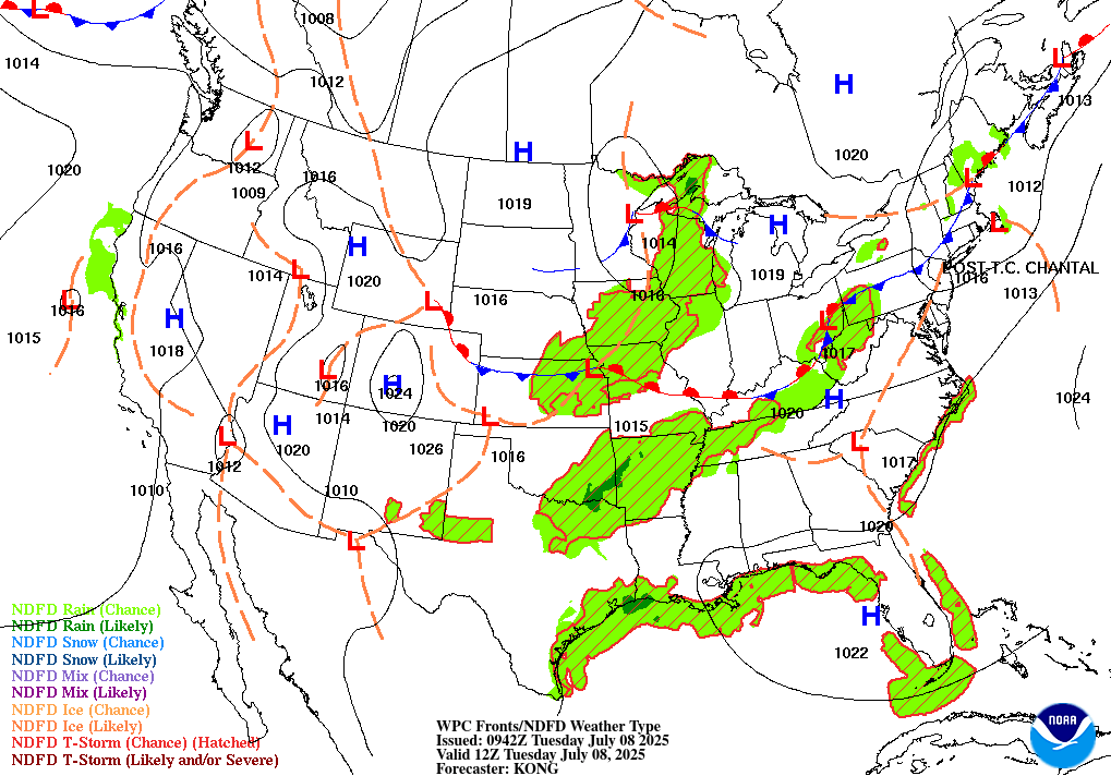
TODAY’S MAP
NWS TECHNICAL DISCUSSION
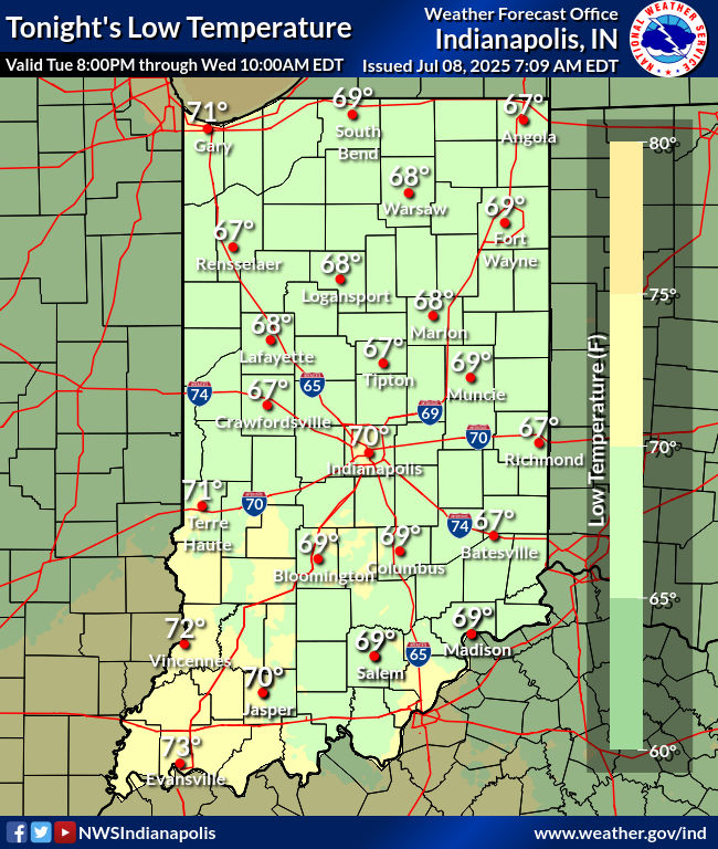
Skies were mainly clear early this morning as weak high pressure had
built in as a remnant frontal boundary had slid south of the Ohio
River. Patchy fog was developing across the forecast area currently
as well. Slightly drier air had advected into the region and
temperatures were cooler as a result in the 60s at 06Z.

The aforementioned high pressure will maintain its influence across
central Indiana for a good portion of the day as it drifts into the
eastern Great Lakes. A stronger upper wave will approach the region
this evening into the overnight and bring an increasing threat for
scattered convection into the western half of the forecast area.

The initial challenge is on continued fog development over the next
few hours as light N/NW flow interacts with damp ground conditions
from rain the last few days and a lingering shallow layer of
moisture within the boundary layer. Coverage should remain scattered
through daybreak but there will likely be spots with locally dense
fog especially across the southeast half of the forecast area where
dewpoints remain higher. Will continue to monitor over the next few
hours.

Much of the day will be quiet with abundant sunshine and light winds
that will eventually return to a S/SW direction. Model soundings
remain suggestive of a diurnal cu field for the afternoon but the
presence of a capping inversion will limit vertical extent to cu at
least through late afternoon.

By this evening...slightly better instability will spread into the
Wabash Valley and may generate isolated convection into the evening.
The focus however will be back across the Missouri and mid
Mississippi Valleys in closer proximity to the upper level wave and
a subtle surface low. More widespread convection will develop late
today in the vicinity of this feature spreading east this evening into
tonight. There is low potential for a brief wind threat with
these storms as they approach but the development of the nocturnal
inversion will support increasingly elevated convection as the
storms arrive into the Wabash Valley in a weakened state later
this evening. Will focus highest precip chances over the
northwest half of the area tonight...with brief heavy rainfall
again being the primary concern from convection.

Temps...low level thermals support highs into the mid and upper 80s
this afternoon but dewpoints are likely to hold in the low to mid
60s through late day which will keep comfortable humidity levels in
play. Moisture will increase tonight with the approaching upper
level wave with lows reverting back to the upper 60s and lower 70s
in response.

&&

.LONG TERM (Wednesday through Monday)...
Issued at 305 AM EDT Tue Jul 8 2025

A progressive weather pattern develops over much of the country
through next week featuring several weak shortwaves and associated
surface features bringing several chances for thunderstorms across
Central Indiana.

A digging trough and associated shortwave dive southeastward from
the Dakotas and into the Great Lakes Tuesday night bringing the next
chance for showers and storms to the region. The surface feature
associated with this synoptic system is fairly weak and diffuse, so
expect mid range models to struggle with the evolution of the
surface pattern and placement of areas of greatest convective
activity.  This will likely be a set up where micro to mesoscale
features develop Tuesday in the Central Plains then propagate
eastward into the state along and just ahead of the upper trough
axis. Latest guidance shows upstream convective activity struggling
to make it eastward into Indiana Wednesday morning. Depending on the
evolution of morning convection, the placement of the weak surface
feature, and how quickly the environment can recover Wednesday
afternoon, there may be another round of storms during peak heating
of the day and into the evening hours. With how weak forcing is
within a warm, humid, and very unstable environment, expect slower
moving storms to develop along micro to mesoscale boundaries,
further enhanced by outflow boundaries of dying storms. This pattern
tends to lead to slow moving storms with a higher potential for
localized flash flooding in areas that see repeated rounds of
storms. Severe weather threat is fairly low, however a strong wind
gust is certainly possible in any storm that collapses.

The upper trough and associated surface wave exit to the east by
Wednesday night, leaving lee side subsidence building across Indiana
into Thursday as a subtle upper ridge axis builds across the upper
midwest. Expect a brief drying trend Wednesday evening into the
first half of Friday as subsidence under the ridge prevents
convective activity from developing. A warm and fairly humid airmass
will still remain in place at the surface with highs in the mid 80s
to near 90.

A better threat for more widespread thunderstorms and potentially
severe weather arrives Friday into Saturday as a much deeper trough
and stronger front approach from the west. Lower confidence exists
on timing and finer details of this system being so far out in time.
At the moment, a stronger low level jet overhead combined with a
moist, unstable surface airmass, and better forcing may lead to a
set up more conducive for organized convective activity and a few
severe storms. Timing is still uncertain as some guidance brings
precipitation in by Friday afternoon, while others slow the system
down and bring storms in on Saturday. For now, keeping Chance PoPs
for Friday with a better chance for storms earlier on Saturday. Will
fine tune the precipitation forecast and timing as confidence
increases.

High pressure pressure and subtle ridging post front should lead to
a drier end to the weekend and beginning of next week with
temperatures near normal for this time of year.

Overall, the days to watch in the extended are Wednesday and
Saturday for the most active, and potentially impactful weather
conditions.
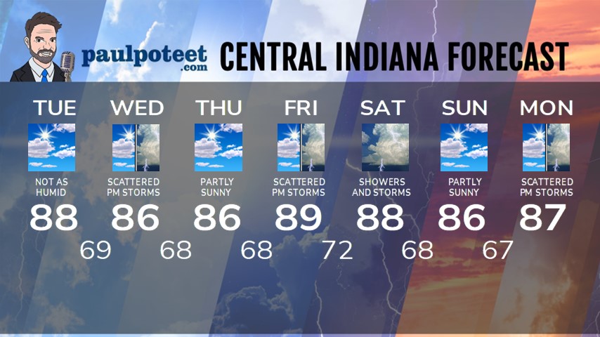
INDY SEVEN DAY FORECAST
Today: Patchy morning fog, then mostly sunny. Not as humid as yesterday. High 88.
Tonight: Partly cloudy. Spotty shower or storm possible late evening and overnight. Low 69.
Wednesday: Partly to mostly cloudy. Scattered showers and storms, mainly in the afternoon. High 86.
Wednesday Night: Partly cloudy. Spotty shower or storm possible. Low 68.
Thursday: Partly sunny. High 86.
Thursday Night: Partly cloudy. Low 68.
Friday: Partly sunny, with scattered showers and storms, mainly in the afternoon. High 89.
Friday Night: Scattered showers and storms. Low 72.
Saturday: Partly to mostly cloudy, with periods of showers and storms. High 88.
Saturday Night: Scattered showers and storms. Low 68.
Sunday: Partly sunny. High 86.
Sunday Night: Partly cloudy. Low 67.
Monday: Partly to mostly cloudy. Scattered showers and storms, mainly in the afternoon. High 87.


Never miss me! Subscribe for free. My Huge Radar has real-time weather tracking, current temperatures, and severe weather watches and warnings. Get detailed Indiana conditions by clicking here. Click here to see my central Indiana 7-Day Forecast. Follow these links to get my forecasts for Lafayette, Muncie, Hendricks County, and Hamilton County. Need a second opinion? Click here for central Indiana National Weather Service forecasts. (Some charts via WeatherBELL.)


